Itapé geodata
Itapé (Guairá) is a populated place; located in Paraguay in America/Asuncion (GMT-4) time zone. With population of 1,641 people, there are 119 cities with bigger population in this country. Compared to other cities in Paraguay, 64.2% of cities are located further ↑North; 50% of cities are located further ←West and 62.3% of cities have higher elevation than Itapé. Note1


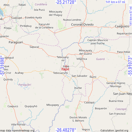
Itapé GPS coordinates[2]
25° 51' 6.192" South, 56° 36' 49.86" West
| Map corner | latitude | longitude |
|---|---|---|
| Upper-left | -25.21728°, | -57.31698° |
| Center: | -25.85172°, | -56.61385° |
| Lower-right: | -26.48278°, | -55.91073° |
| Map W x H: | 140.7×140.7 km | = 87.4×87.4mi |
| max Lat: | -19.91667° ⇑64.2% North |
| Itapé: | -25.85172° |
| min Lat: | ⇓35.8% South -27.38662° |
| min Long | Itapé | max Long |
| -60.78333° | -56.61385° | -54.30694° |
| W 50%⇐ | ⇒50% E |
Elevation
Elevation of Itapé is 126 m = 413 ft, and this is 43.7 m = 143 ft below average elevation for this country.
| Max E: |
658 m = 2159 ft | 62.3% |
| Avg. | 169.7 m = 557 ft | |
| Itapé | 126 m = 413 ft | |
Min E: |
46 m = 151 ft | 37.7% |
See also: Paraguay elevation on elevation.city.
Geographical zone
Itapé is located in South temperate zone (between Tropic of Capricorn and the Antarctic Circle). Distance of this Southern Tropic circle is 268.5 km =166.8 mi to North.| Distance of | km | miles | from Itapé |
|---|---|---|---|
| Equator | 2874.4 | 1786.1 | to North |
| Tropic Capricorn | 268.5 | 166.8 | to North |
| Antarctic Circle | 4526.7 | 2812.8 | to South |
| South Pole | 7132.6 | 4432 | to South |


Nearby cities:
15 places around Itapé: (largest is in red/bold)
• Coronel Martínez
10.4 km =6.5 mi,  358°
358°
• Félix Pérez Cardozo
15.2 km =9.4 mi,  36°
36°
• Independencia
39 km =24.2 mi,  62°
62°
• Iturbe
26 km =16.2 mi,  150°
150°
• La Colmena
23 km =14.3 mi,  260°
260°
• Maciel
39.4 km =24.5 mi,  159°
159°
• Mbocayaty
24.2 km =15 mi,  52°
52°
• Mbuyapey
43.3 km =26.9 mi,  199°
199°
• Natalicio Talavera
39.7 km =24.7 mi, 52°
• San José
37.4 km =23.2 mi,  341°
341°
• Sapucaí
39.6 km =24.6 mi,  301°
301°
• Valenzuela
38.4 km =23.9 mi,  317°
317°
• Villarrica
21.2 km =13.2 mi, 57°
• Ybytymi
21.6 km =13.4 mi, 298°
• Ñumi
30.5 km =19 mi,  111°
111°
Sources, notices
• [Note1] Compared only with cities in Paraguay existing in our database
• [Src1] Map data: © OpenStreetMap contributors (CC-BY-SA)
• [Src2] Other city data from geonames.org with taken over terms of usage.
• [Src3] Geographical zone / Annual Mean Temperature by Robert A. Rohde @ Wikipedia
