Ñumi geodata
Ñumi (Guairá) is a populated place; located in Paraguay in America/Asuncion (GMT-4) time zone. With population of 864 people, there are 143 cities with bigger population in this country. Compared to other cities in Paraguay, 66.7% of cities are located further ↑North; 63% of cities are located further ←West and 53.7% of cities have higher elevation than Ñumi. Note1


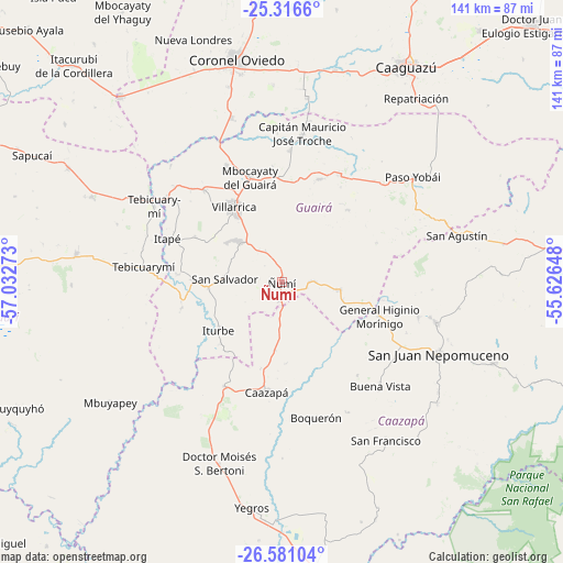
Ñumi GPS coordinates[2]
25° 57' 1.872" South, 56° 19' 46.56" West
| Map corner | latitude | longitude |
|---|---|---|
| Upper-left | -25.3166°, | -57.03273° |
| Center: | -25.95052°, | -56.3296° |
| Lower-right: | -26.58104°, | -55.62648° |
| Map W x H: | 140.6×140.6 km | = 87.4×87.4mi |
| max Lat: | -19.91667° ⇑66.7% North |
| Ñumi: | -25.95052° |
| min Lat: | ⇓33.3% South -27.38662° |
| min Long | Ñumi | max Long |
| -60.78333° | -56.3296° | -54.30694° |
| W 63%⇐ | ⇒37% E |
Elevation
Elevation of Ñumi is 138 m = 453 ft, and this is 31.7 m = 104 ft below average elevation for this country.
| Max E: |
658 m = 2159 ft | 53.7% |
| Avg. | 169.7 m = 557 ft | |
| Ñumi | 138 m = 453 ft | |
Min E: |
46 m = 151 ft | 46.3% |
See also: Paraguay elevation on elevation.city.
Geographical zone
Ñumi is located in South temperate zone (between Tropic of Capricorn and the Antarctic Circle). Distance of this Southern Tropic circle is 279.5 km =173.7 mi to North.| Distance of | km | miles | from Ñumi |
|---|---|---|---|
| Equator | 2885.4 | 1792.9 | to North |
| Tropic Capricorn | 279.5 | 173.7 | to North |
| Antarctic Circle | 4515.7 | 2805.9 | to South |
| South Pole | 7121.6 | 4425.2 | to South |


Nearby cities:
15 places around Ñumi: (largest is in red/bold)
• Abaí
40.7 km =25.3 mi,  103°
103°
• Buena Vista
35.9 km =22.3 mi,  136°
136°
• Caazapá
27.5 km =17.1 mi,  188°
188°
• Colonia Mauricio José Troche
42.9 km =26.7 mi,  6°
6°
• Coronel Martínez
35.8 km =22.2 mi,  306°
306°
• Félix Pérez Cardozo
30.2 km =18.8 mi,  320°
320°
• General Higinio Morínigo
41.3 km =25.7 mi,  89°
89°
• Independencia
29.5 km =18.3 mi, 12°
• Itapé
30.5 km =19 mi,  291°
291°
• Iturbe
19.4 km =12.1 mi,  233°
233°
• Maciel
29.5 km =18.3 mi,  208°
208°
• Mbocayaty
27.3 km =17 mi,  340°
340°
• Natalicio Talavera
35.4 km =22 mi,  4°
4°
• San Juan Nepomuceno
43 km =26.7 mi,  114°
114°
• Villarrica
24.7 km =15.3 mi,  334°
334°
Sources, notices
• [Note1] Compared only with cities in Paraguay existing in our database
• [Src1] Map data: © OpenStreetMap contributors (CC-BY-SA)
• [Src2] Other city data from geonames.org with taken over terms of usage.
• [Src3] Geographical zone / Annual Mean Temperature by Robert A. Rohde @ Wikipedia
