Sălcuța geodata
Sălcuța (Dâmboviţa) is a populated place; located in Romania in Europe/Bucharest (GMT+3) time zone. With population of 1,476 people, there are 3220 cities with bigger population in this country. Compared to other cities in Romania, 81.7% of cities are located further ↑North; 55.8% of cities are located further ←West and 63.7% of cities have higher elevation than Sălcuța. Note1


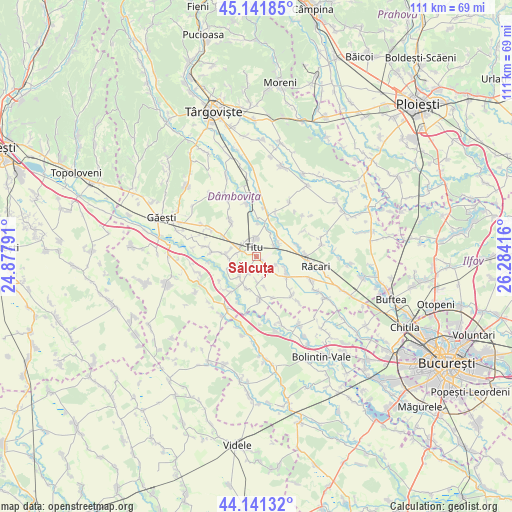
Sălcuța GPS coordinates[2]
44° 38' 37.464" North, 25° 34' 51.708" East
| Map corner | latitude | longitude |
|---|---|---|
| Upper-left | 45.14185°, | 24.87791° |
| Center: | 44.64374°, | 25.58103° |
| Lower-right: | 44.14132°, | 26.28416° |
| Map W x H: | 111.2×111.2 km | = 69.1×69.1mi |
| max Lat: | 48.23793° ⇑81.7% North |
| Sălcuța: | 44.64374° |
| min Lat: | ⇓18.3% South 43.65638° |
| min Long | Sălcuța | max Long |
| 20.31667° | 25.58103° | 29.65403° |
| W 55.8%⇐ | ⇒44.2% E |
Elevation
Elevation of Sălcuța is 152 m = 499 ft, and this is 102.9 m = 338 ft below average elevation for this country.
| Max E: |
1278 m = 4193 ft | 63.7% |
| Avg. | 254.9 m = 836 ft | |
| Sălcuța | 152 m = 499 ft | |
Min E: |
-2 m = -7 ft | 36.3% |
See also: Romania elevation on elevation.city.
Geographical zone
Sălcuța is located in North temperate zone (between Tropic of Cancer and the Arctic Circle). Distance of this Northern Tropic circle is 2358 km =1465.2 mi to South.| Distance of | km | miles | from Sălcuța |
|---|---|---|---|
| North Pole | 5043.1 | 3133.6 | to North |
| Arctic Circle | 2437.3 | 1514.5 | to North |
| Tropic Cancer | 2358 | 1465.2 | to South |
| Equator | 4963.9 | 3084.4 | to South |


Nearby cities:
15 places around Sălcuța: (largest is in red/bold)
• Boteni
4.5 km =2.8 mi,  58°
58°
• Braniştea
4.4 km =2.7 mi,  2°
2°
• Brâncoveanu
5.2 km =3.2 mi,  220°
220°
• Conțești
6.5 km =4 mi,  44°
44°
• Dâmbovicioara
4.2 km =2.6 mi,  328°
328°
• Fusea
4.2 km =2.6 mi,  298°
298°
• Hagioaica
4.2 km =2.6 mi,  311°
311°
• Lunguleţu
6.2 km =3.9 mi,  118°
118°
• Mărunțișu
6.2 km =3.9 mi,  252°
252°
• Odobeşti
3.2 km =2 mi,  200°
200°
• Pitaru
5.9 km =3.7 mi,  177°
177°
• Plopu
4.4 km =2.7 mi,  280°
280°
• Serdanu
4.4 km =2.7 mi,  114°
114°
• Titu
3.8 km =2.4 mi, 280°
• Tomșani
6.2 km =3.9 mi,  267°
267°
Sources, notices
• [Note1] Compared only with cities in Romania existing in our database
• [Src1] Map data: © OpenStreetMap contributors (CC-BY-SA)
• [Src2] Other city data from geonames.org with taken over terms of usage.
• [Src3] Geographical zone / Annual Mean Temperature by Robert A. Rohde @ Wikipedia
