Vlădeşti geodata
Vlădeşti (Galaţi) is a seat of a second-order administrative division; located in Romania in Europe/Bucharest (GMT+3) time zone. With population of 2,228 people, there are 2393 cities with bigger population in this country. Compared to other cities in Romania, 51.4% of cities are located further ↓South; 97% of cities are located further ←West and 90.9% of cities have higher elevation than Vlădeşti. Note1


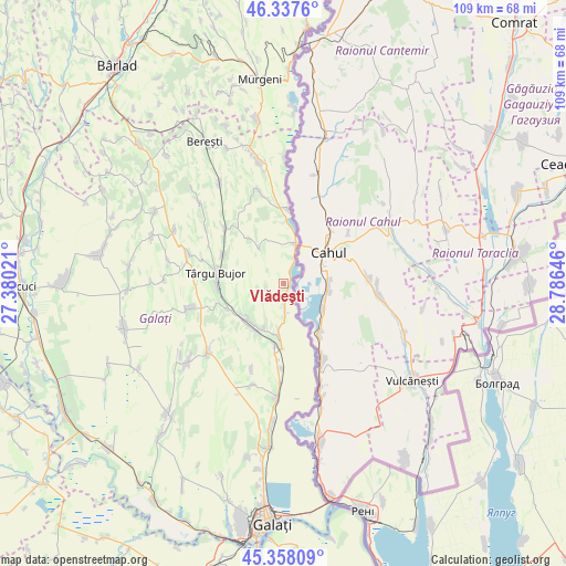
Vlădeşti GPS coordinates[2]
45° 51' 0" North, 28° 4' 59.988" East
| Map corner | latitude | longitude |
|---|---|---|
| Upper-left | 46.3376°, | 27.38021° |
| Center: | 45.85°, | 28.08333° |
| Lower-right: | 45.35809°, | 28.78646° |
| Map W x H: | 108.9×108.9 km | = 67.7×67.7mi |
| max Lat: | 48.23793° ⇑48.6% North |
| Vlădeşti: | 45.85° |
| min Lat: | ⇓51.4% South 43.65638° |
| min Long | Vlădeşti | max Long |
| 20.31667° | 28.08333° | 29.65403° |
| W 97%⇐ | ⇒3% E |
Elevation
Elevation of Vlădeşti is 54 m = 177 ft, and this is 200.9 m = 659 ft below average elevation for this country.
| Max E: |
1278 m = 4193 ft | 90.9% |
| Avg. | 254.9 m = 836 ft | |
| Vlădeşti | 54 m = 177 ft | |
Min E: |
-2 m = -7 ft | 9.1% |
See also: Romania elevation on elevation.city.
Geographical zone
Vlădeşti is located in North temperate zone (between Tropic of Cancer and the Arctic Circle). Distance of this North polar circle is 2303.1 km =1431.1 mi to North.| Distance of | km | miles | from Vlădeşti |
|---|---|---|---|
| North Pole | 4909 | 3050.3 | to North |
| Arctic Circle | 2303.1 | 1431.1 | to North |
| Tropic Cancer | 2492.1 | 1548.5 | to South |
| Equator | 5098 | 3167.7 | to South |


Nearby cities:
15 places around Vlădeşti: (largest is in red/bold)
• Brănești
5.3 km =3.3 mi,  177°
177°
• Băneasa
14.9 km =9.3 mi,  308°
308°
• Chiraftei
9.7 km =6 mi,  206°
206°
• Folteşti
11.4 km =7.1 mi,  193°
193°
• Fântânele
17.6 km =10.9 mi,  200°
200°
• Fârţăneşti
8.6 km =5.3 mi,  244°
244°
• Moscu
13.1 km =8.1 mi,  296°
296°
• Măstăcani
8.4 km =5.2 mi, 207°
• Oancea
7.5 km =4.7 mi,  9°
9°
• Rogojeni
14.5 km =9 mi,  2°
2°
• Roșcani
8.4 km =5.2 mi,  326°
326°
• Stoicani
16.2 km =10.1 mi, 181°
• Târgu Bujor
14.3 km =8.9 mi,  277°
277°
• Umbrărești
12.8 km =8 mi,  269°
269°
• Viile
11.6 km =7.2 mi,  245°
245°
Sources, notices
• [Note1] Compared only with cities in Romania existing in our database
• [Src1] Map data: © OpenStreetMap contributors (CC-BY-SA)
• [Src2] Other city data from geonames.org with taken over terms of usage.
• [Src3] Geographical zone / Annual Mean Temperature by Robert A. Rohde @ Wikipedia
