Chilieni geodata
Chilieni (Covasna) is a populated place; located in Romania in Europe/Bucharest (GMT+3) time zone. With population of 642 people, there are 5926 cities with bigger population in this country. Compared to other cities in Romania, 51.2% of cities are located further ↓South; 59.2% of cities are located further ←West and 90.7% of cities have lower elevation than Chilieni. Note1


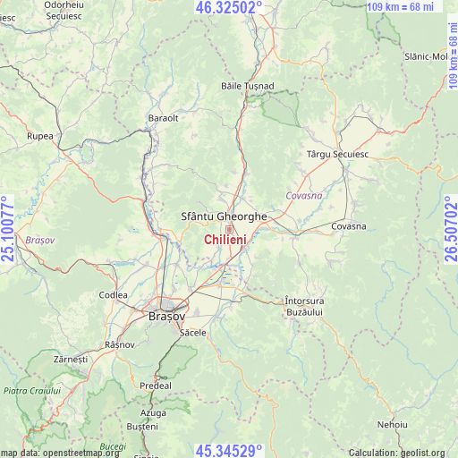
Chilieni GPS coordinates[2]
45° 50' 14.316" North, 25° 48' 14.004" East
| Map corner | latitude | longitude |
|---|---|---|
| Upper-left | 46.32502°, | 25.10077° |
| Center: | 45.83731°, | 25.80389° |
| Lower-right: | 45.34529°, | 26.50702° |
| Map W x H: | 108.9×108.9 km | = 67.7×67.7mi |
| max Lat: | 48.23793° ⇑48.8% North |
| Chilieni: | 45.83731° |
| min Lat: | ⇓51.2% South 43.65638° |
| min Long | Chilieni | max Long |
| 20.31667° | 25.80389° | 29.65403° |
| W 59.2%⇐ | ⇒40.8% E |
Elevation
Elevation of Chilieni is 525 m = 1722 ft, and this is 270.1 m = 886 ft above average elevation for this country.
| Max E: |
1278 m = 4193 ft | 9.3% |
| Chilieni | 525 m 1722 ft | |
| Avg. | 254.9 m = 836 ft | |
Min E: |
-2 m = -7 ft | 90.7% |
See also: Romania elevation on elevation.city.
Geographical zone
Chilieni is located in North temperate zone (between Tropic of Cancer and the Arctic Circle). Distance of this North polar circle is 2304.5 km =1431.9 mi to North.| Distance of | km | miles | from Chilieni |
|---|---|---|---|
| North Pole | 4910.4 | 3051.2 | to North |
| Arctic Circle | 2304.5 | 1431.9 | to North |
| Tropic Cancer | 2490.7 | 1547.6 | to South |
| Equator | 5096.6 | 3166.9 | to South |


Nearby cities:
15 places around Chilieni: (largest is in red/bold)
• Angheluș
7.9 km =4.9 mi,  54°
54°
• Araci
11.9 km =7.4 mi,  256°
256°
• Arcuș
7.4 km =4.6 mi,  343°
343°
• Calnic
10.8 km =6.7 mi,  351°
351°
• Chichiş
6 km =3.7 mi,  182°
182°
• Dobolii de Jos
7.1 km =4.4 mi,  210°
210°
• Ghidfalău
7.8 km =4.8 mi,  27°
27°
• Ilieni
5.1 km =3.2 mi, 214°
• Ozun
5.5 km =3.4 mi,  139°
139°
• Podu Oltului
10.6 km =6.6 mi,  216°
216°
• Reci
10.1 km =6.3 mi,  81°
81°
• Sfântu Gheorghe
3.6 km =2.2 mi,  333°
333°
• Sântionlunca
5.7 km =3.5 mi,  104°
104°
• Valea Crişului
9.3 km =5.8 mi, 341°
• Vâlcele
9.4 km =5.8 mi,  278°
278°
Sources, notices
• [Note1] Compared only with cities in Romania existing in our database
• [Src1] Map data: © OpenStreetMap contributors (CC-BY-SA)
• [Src2] Other city data from geonames.org with taken over terms of usage.
• [Src3] Geographical zone / Annual Mean Temperature by Robert A. Rohde @ Wikipedia
