Sfântu Gheorghe geodata
Sfântu Gheorghe (Covasna) is a seat of a first-order administrative division; located in Romania in Europe/Bucharest (GMT+3) time zone. With population of 60,677 people, there are 45 cities with bigger population in this country. Compared to other cities in Romania, 51.8% of cities are located further ↓South; 58.8% of cities are located further ←West and 92.2% of cities have lower elevation than Sfântu Gheorghe. Note1


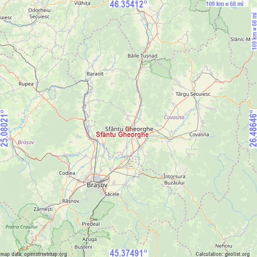
Sfântu Gheorghe GPS coordinates[2]
45° 52' 0.012" North, 25° 46' 59.988" East
| Map corner | latitude | longitude |
|---|---|---|
| Upper-left | 46.35412°, | 25.08021° |
| Center: | 45.86667°, | 25.78333° |
| Lower-right: | 45.37491°, | 26.48646° |
| Map W x H: | 108.9×108.9 km | = 67.7×67.7mi |
| max Lat: | 48.23793° ⇑48.2% North |
| Sfântu Gheorghe: | 45.86667° |
| min Lat: | ⇓51.8% South 43.65638° |
| min Long | Sfântu Gheorgh | max Long |
| 20.31667° | 25.78333° | 29.65403° |
| W 58.8%⇐ | ⇒41.2% E |
Elevation
Elevation of Sfântu Gheorghe is 552 m = 1811 ft, and this is 297.1 m = 975 ft above average elevation for this country.
| Max E: |
1278 m = 4193 ft | 7.8% |
| Sfântu Gheorghe | 552 m 1811 ft | |
| Avg. | 254.9 m = 836 ft | |
Min E: |
-2 m = -7 ft | 92.2% |
See also: Sfântu Gheorghe elevation on elevation.city.
Geographical zone
Sfântu Gheorghe is located in North temperate zone (between Tropic of Cancer and the Arctic Circle). Distance of this North polar circle is 2301.3 km =1430 mi to North.| Distance of | km | miles | from Sfântu Gheorghe |
|---|---|---|---|
| North Pole | 4907.2 | 3049.2 | to North |
| Arctic Circle | 2301.3 | 1430 | to North |
| Tropic Cancer | 2494 | 1549.7 | to South |
| Equator | 5099.9 | 3168.9 | to South |


Nearby cities:
15 places around Sfântu Gheorghe: (largest is in red/bold)
• Angheluș
8.1 km =5 mi,  80°
80°
• Araci
11.7 km =7.3 mi,  238°
238°
• Arcuș
3.8 km =2.4 mi,  352°
352°
• Bodoc
10.6 km =6.6 mi,  29°
29°
• Calnic
7.4 km =4.6 mi,  0°
0°
• Chichiş
9.4 km =5.8 mi,  172°
172°
• Chilieni
3.6 km =2.2 mi,  153°
153°
• Dobolii de Jos
9.6 km =6 mi,  192°
192°
• Ghidfalău
6.4 km =4 mi,  54°
54°
• Ilieni
7.5 km =4.7 mi, 189°
• Ozun
9 km =5.6 mi, 145°
• Sântionlunca
8.5 km =5.3 mi,  123°
123°
• Valea Crişului
5.7 km =3.5 mi, 346°
• Vâlcele
8 km =5 mi,  256°
256°
• Zălan
10.7 km =6.6 mi,  14°
14°
Sources, notices
• [Note1] Compared only with cities in Romania existing in our database
• [Src1] Map data: © OpenStreetMap contributors (CC-BY-SA)
• [Src2] Other city data from geonames.org with taken over terms of usage.
• [Src3] Geographical zone / Annual Mean Temperature by Robert A. Rohde @ Wikipedia
