Lăpuşnicel geodata
Lăpuşnicel (Caraş-Severin) is a seat of a second-order administrative division; located in Romania in Europe/Bucharest (GMT+3) time zone. With population of 1,279 people, there are 3564 cities with bigger population in this country. Compared to other cities in Romania, 70.4% of cities are located further ↑North; 92.6% of cities are located further →East and 79.4% of cities have lower elevation than Lăpuşnicel. Note1


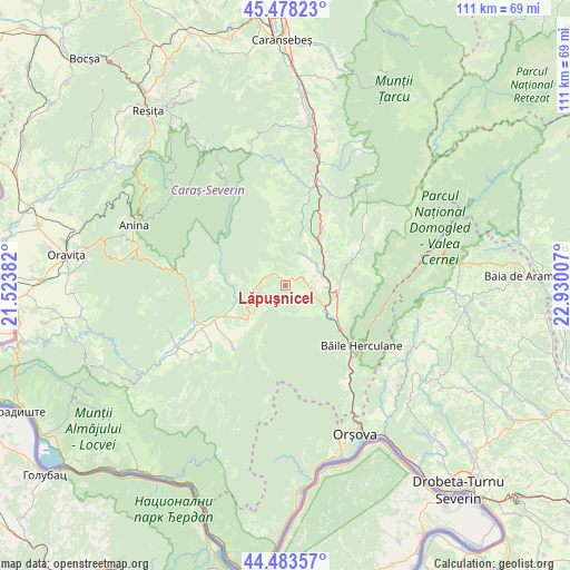
Lăpuşnicel GPS coordinates[2]
44° 58' 59.016" North, 22° 13' 36.984" East
| Map corner | latitude | longitude |
|---|---|---|
| Upper-left | 45.47823°, | 21.52382° |
| Center: | 44.98306°, | 22.22694° |
| Lower-right: | 44.48357°, | 22.93007° |
| Map W x H: | 110.6×110.6 km | = 68.7×68.7mi |
| max Lat: | 48.23793° ⇑70.4% North |
| Lăpuşnicel: | 44.98306° |
| min Lat: | ⇓29.6% South 43.65638° |
| min Long | Lăpuşnicel | max Long |
| 20.31667° | 22.22694° | 29.65403° |
| W 7.4%⇐ | ⇒92.6% E |
Elevation
Elevation of Lăpuşnicel is 388 m = 1273 ft, and this is 133.1 m = 437 ft above average elevation for this country.
| Max E: |
1278 m = 4193 ft | 20.6% |
| Lăpuşnicel | 388 m 1273 ft | |
| Avg. | 254.9 m = 836 ft | |
Min E: |
-2 m = -7 ft | 79.4% |
See also: Romania elevation on elevation.city.
Geographical zone
Lăpuşnicel is located in North temperate zone (between Tropic of Cancer and the Arctic Circle). Distance of this Northern Tropic circle is 2395.7 km =1488.6 mi to South.| Distance of | km | miles | from Lăpuşnicel |
|---|---|---|---|
| North Pole | 5005.4 | 3110.2 | to North |
| Arctic Circle | 2399.5 | 1491 | to North |
| Tropic Cancer | 2395.7 | 1488.6 | to South |
| Equator | 5001.6 | 3107.8 | to South |


Nearby cities:
15 places around Lăpuşnicel: (largest is in red/bold)
• Borlovenii Noi
6.8 km =4.2 mi,  256°
256°
• Borlovenii Vechi
9.7 km =6 mi,  251°
251°
• Cornea
9 km =5.6 mi,  51°
51°
• Crușovăț
7.5 km =4.7 mi,  78°
78°
• Cuptoare
7.1 km =4.4 mi,  64°
64°
• Globu Craiovei
3.7 km =2.3 mi,  68°
68°
• Iablaniţa
7.8 km =4.8 mi,  117°
117°
• Luncaviţa
11.6 km =7.2 mi,  15°
15°
• Mehadica
6.4 km =4 mi,  29°
29°
• Petnic
5 km =3.1 mi,  96°
96°
• Plugova
10.6 km =6.6 mi, 102°
• Prigor
10.2 km =6.3 mi,  240°
240°
• Pârvova
3.9 km =2.4 mi,  335°
335°
• Pătaș
10.5 km =6.5 mi, 250°
• Verendin
10.6 km =6.6 mi,  5°
5°
Sources, notices
• [Note1] Compared only with cities in Romania existing in our database
• [Src1] Map data: © OpenStreetMap contributors (CC-BY-SA)
• [Src2] Other city data from geonames.org with taken over terms of usage.
• [Src3] Geographical zone / Annual Mean Temperature by Robert A. Rohde @ Wikipedia
