Pârvova geodata
Pârvova (Caraş-Severin) is a populated place; located in Romania in Europe/Bucharest (GMT+3) time zone. With population of 702 people, there are 5559 cities with bigger population in this country. Compared to other cities in Romania, 69.4% of cities are located further ↑North; 92.7% of cities are located further →East and 81.9% of cities have lower elevation than Pârvova. Note1


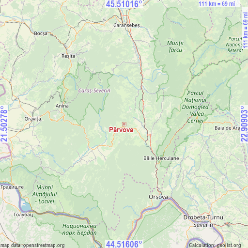
Pârvova GPS coordinates[2]
45° 0' 54.972" North, 22° 12' 21.24" East
| Map corner | latitude | longitude |
|---|---|---|
| Upper-left | 45.51016°, | 21.50278° |
| Center: | 45.01527°, | 22.2059° |
| Lower-right: | 44.51606°, | 22.90903° |
| Map W x H: | 110.5×110.5 km | = 68.7×68.7mi |
| max Lat: | 48.23793° ⇑69.4% North |
| Pârvova: | 45.01527° |
| min Lat: | ⇓30.6% South 43.65638° |
| min Long | Pârvova | max Long |
| 20.31667° | 22.2059° | 29.65403° |
| W 7.3%⇐ | ⇒92.7% E |
Elevation
Elevation of Pârvova is 411 m = 1348 ft, and this is 156.1 m = 512 ft above average elevation for this country.
| Max E: |
1278 m = 4193 ft | 18.1% |
| Pârvova | 411 m 1348 ft | |
| Avg. | 254.9 m = 836 ft | |
Min E: |
-2 m = -7 ft | 81.9% |
See also: Romania elevation on elevation.city.
Geographical zone
Pârvova is located in North temperate zone (between Tropic of Cancer and the Arctic Circle). Distance of this North polar circle is 2395.9 km =1488.7 mi to North.| Distance of | km | miles | from Pârvova |
|---|---|---|---|
| North Pole | 5001.8 | 3108 | to North |
| Arctic Circle | 2395.9 | 1488.7 | to North |
| Tropic Cancer | 2399.3 | 1490.9 | to South |
| Equator | 5005.2 | 3110.1 | to South |


Nearby cities:
15 places around Pârvova: (largest is in red/bold)
• Borlovenii Noi
7.1 km =4.4 mi,  223°
223°
• Borlovenii Vechi
10.1 km =6.3 mi,  228°
228°
• Cornea
8.9 km =5.5 mi,  77°
77°
• Crușovăț
9.2 km =5.7 mi,  102°
102°
• Cuptoare
8.1 km =5 mi,  93°
93°
• Domaşnea
11.5 km =7.1 mi,  48°
48°
• Globu Craiovei
5.6 km =3.5 mi,  113°
113°
• Iablaniţa
11.2 km =7 mi,  130°
130°
• Luncaviţa
8.9 km =5.5 mi,  32°
32°
• Lăpuşnicel
3.9 km =2.4 mi,  155°
155°
• Mehadica
5.2 km =3.2 mi,  67°
67°
• Petnic
7.8 km =4.8 mi,  121°
121°
• Prigor
11.2 km =7 mi, 220°
• Pătaș
10.9 km =6.8 mi, 229°
• Verendin
7.4 km =4.6 mi,  20°
20°
Sources, notices
• [Note1] Compared only with cities in Romania existing in our database
• [Src1] Map data: © OpenStreetMap contributors (CC-BY-SA)
• [Src2] Other city data from geonames.org with taken over terms of usage.
• [Src3] Geographical zone / Annual Mean Temperature by Robert A. Rohde @ Wikipedia
