Vaţa de Jos geodata
Vaţa de Jos (Hunedoara) is a populated place; located in Romania in Europe/Bucharest (GMT+3) time zone. With population of 4,239 people, there are 1080 cities with bigger population in this country. Compared to other cities in Romania, 59.1% of cities are located further ↓South; 88.9% of cities are located further →East and 53.1% of cities have lower elevation than Vaţa de Jos. Note1


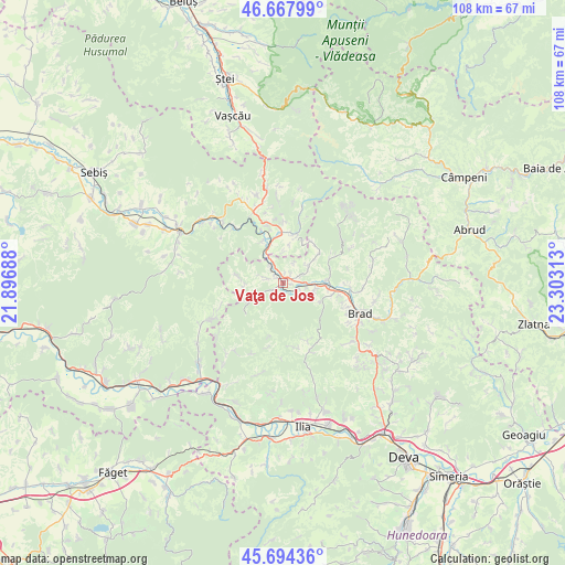
Vaţa de Jos GPS coordinates[2]
46° 10' 59.988" North, 22° 36' 0" East
| Map corner | latitude | longitude |
|---|---|---|
| Upper-left | 46.66799°, | 21.89688° |
| Center: | 46.18333°, | 22.6° |
| Lower-right: | 45.69436°, | 23.30313° |
| Map W x H: | 108.3×108.3 km | = 67.3×67.3mi |
| max Lat: | 48.23793° ⇑40.9% North |
| Vaţa de Jos: | 46.18333° |
| min Lat: | ⇓59.1% South 43.65638° |
| min Long | Vaţa de Jos | max Long |
| 20.31667° | 22.6° | 29.65403° |
| W 11.1%⇐ | ⇒88.9% E |
Elevation
Elevation of Vaţa de Jos is 228 m = 748 ft, and this is 26.9 m = 88 ft below average elevation for this country.
| Max E: |
1278 m = 4193 ft | 46.9% |
| Avg. | 254.9 m = 836 ft | |
| Vaţa de Jos | 228 m = 748 ft | |
Min E: |
-2 m = -7 ft | 53.1% |
See also: Romania elevation on elevation.city.
Geographical zone
Vaţa de Jos is located in North temperate zone (between Tropic of Cancer and the Arctic Circle). Distance of this North polar circle is 2266.1 km =1408.1 mi to North.| Distance of | km | miles | from Vaţa de Jos |
|---|---|---|---|
| North Pole | 4872 | 3027.3 | to North |
| Arctic Circle | 2266.1 | 1408.1 | to North |
| Tropic Cancer | 2529.2 | 1571.6 | to South |
| Equator | 5135.1 | 3190.8 | to South |


Nearby cities:
15 places around Vaţa de Jos: (largest is in red/bold)
• Baia de Criş
9.2 km =5.7 mi,  101°
101°
• Brad
15.2 km =9.4 mi,  111°
111°
• Bulzeștii de Sus
18 km =11.2 mi,  43°
43°
• Crișan
15.3 km =9.5 mi, 95°
• Hălmagiu
9.4 km =5.8 mi,  352°
352°
• Hălmăgel
9.4 km =5.8 mi,  7°
7°
• Luncoiu de Jos
15.8 km =9.8 mi,  125°
125°
• Luncșoara
15.5 km =9.6 mi, 7°
• Mesteacăn
13.3 km =8.3 mi, 109°
• Ribiţa
12.8 km =8 mi,  90°
90°
• Rișculița
10.5 km =6.5 mi,  62°
62°
• Tomeşti
5.3 km =3.3 mi,  46°
46°
• Tălagiu
14.3 km =8.9 mi,  317°
317°
• Vârfurile
16.2 km =10.1 mi,  336°
336°
• Țebea
9.7 km =6 mi, 105°
Sources, notices
• [Note1] Compared only with cities in Romania existing in our database
• [Src1] Map data: © OpenStreetMap contributors (CC-BY-SA)
• [Src2] Other city data from geonames.org with taken over terms of usage.
• [Src3] Geographical zone / Annual Mean Temperature by Robert A. Rohde @ Wikipedia
