Hălmagiu geodata
Hălmagiu (Arad) is a seat of a second-order administrative division; located in Romania in Europe/Bucharest (GMT+3) time zone. With population of 3,507 people, there are 1421 cities with bigger population in this country. Compared to other cities in Romania, 61.1% of cities are located further ↓South; 89.1% of cities are located further →East and 55.4% of cities have lower elevation than Hălmagiu. Note1


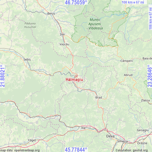
Hălmagiu GPS coordinates[2]
46° 16' 0.012" North, 22° 34' 59.988" East
| Map corner | latitude | longitude |
|---|---|---|
| Upper-left | 46.75059°, | 21.88021° |
| Center: | 46.26667°, | 22.58333° |
| Lower-right: | 45.77844°, | 23.28646° |
| Map W x H: | 108.1×108.1 km | = 67.2×67.2mi |
| max Lat: | 48.23793° ⇑38.9% North |
| Hălmagiu: | 46.26667° |
| min Lat: | ⇓61.1% South 43.65638° |
| min Long | Hălmagiu | max Long |
| 20.31667° | 22.58333° | 29.65403° |
| W 10.9%⇐ | ⇒89.1% E |
Elevation
Elevation of Hălmagiu is 240 m = 787 ft, and this is 14.9 m = 49 ft below average elevation for this country.
| Max E: |
1278 m = 4193 ft | 44.6% |
| Avg. | 254.9 m = 836 ft | |
| Hălmagiu | 240 m = 787 ft | |
Min E: |
-2 m = -7 ft | 55.4% |
See also: Romania elevation on elevation.city.
Geographical zone
Hălmagiu is located in North temperate zone (between Tropic of Cancer and the Arctic Circle). Distance of this North polar circle is 2256.8 km =1402.3 mi to North.| Distance of | km | miles | from Hălmagiu |
|---|---|---|---|
| North Pole | 4862.7 | 3021.5 | to North |
| Arctic Circle | 2256.8 | 1402.3 | to North |
| Tropic Cancer | 2538.5 | 1577.4 | to South |
| Equator | 5144.4 | 3196.6 | to South |


Nearby cities:
15 places around Hălmagiu: (largest is in red/bold)
• Avram Iancu
13.7 km =8.5 mi,  313°
313°
• Baia de Criş
15.1 km =9.4 mi,  137°
137°
• Bulzeștii de Sus
14.2 km =8.8 mi,  74°
74°
• Criştioru de Jos
17.4 km =10.8 mi,  347°
347°
• Hălmăgel
2.6 km =1.6 mi,  90°
90°
• Lazuri
8.7 km =5.4 mi, 347°
• Luncșoara
7 km =4.3 mi,  29°
29°
• Pleşcuţa
12.1 km =7.5 mi,  287°
287°
• Ribiţa
16.9 km =10.5 mi,  123°
123°
• Rișculița
11.5 km =7.1 mi,  112°
112°
• Tomeşti
7.6 km =4.7 mi, 137°
• Tălagiu
8.5 km =5.3 mi,  278°
278°
• Vaţa de Jos
9.4 km =5.8 mi,  172°
172°
• Vârfurile
7.6 km =4.7 mi,  317°
317°
• Țebea
15.9 km =9.9 mi, 138°
Sources, notices
• [Note1] Compared only with cities in Romania existing in our database
• [Src1] Map data: © OpenStreetMap contributors (CC-BY-SA)
• [Src2] Other city data from geonames.org with taken over terms of usage.
• [Src3] Geographical zone / Annual Mean Temperature by Robert A. Rohde @ Wikipedia
