Țebea geodata
Țebea (Hunedoara) is a populated place; located in Romania in Europe/Bucharest (GMT+3) time zone. With population of 849 people, there are 4845 cities with bigger population in this country. Compared to other cities in Romania, 58.8% of cities are located further ↓South; 87.9% of cities are located further →East and 62.2% of cities have lower elevation than Țebea. Note1


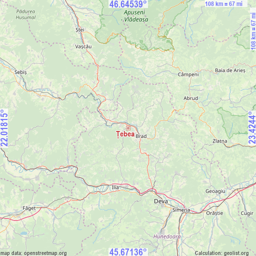
Țebea GPS coordinates[2]
46° 9' 37.908" North, 22° 43' 16.572" East
| Map corner | latitude | longitude |
|---|---|---|
| Upper-left | 46.64539°, | 22.01815° |
| Center: | 46.16053°, | 22.72127° |
| Lower-right: | 45.67136°, | 23.4244° |
| Map W x H: | 108.3×108.3 km | = 67.3×67.3mi |
| max Lat: | 48.23793° ⇑41.2% North |
| Țebea: | 46.16053° |
| min Lat: | ⇓58.8% South 43.65638° |
| min Long | Țebea | max Long |
| 20.31667° | 22.72127° | 29.65403° |
| W 12.1%⇐ | ⇒87.9% E |
Elevation
Elevation of Țebea is 275 m = 902 ft, and this is 20.1 m = 66 ft above average elevation for this country.
| Max E: |
1278 m = 4193 ft | 37.8% |
| Țebea | 275 m 902 ft | |
| Avg. | 254.9 m = 836 ft | |
Min E: |
-2 m = -7 ft | 62.2% |
See also: Romania elevation on elevation.city.
Geographical zone
Țebea is located in North temperate zone (between Tropic of Cancer and the Arctic Circle). Distance of this North polar circle is 2268.6 km =1409.6 mi to North.| Distance of | km | miles | from Țebea |
|---|---|---|---|
| North Pole | 4874.5 | 3028.9 | to North |
| Arctic Circle | 2268.6 | 1409.6 | to North |
| Tropic Cancer | 2526.7 | 1570 | to South |
| Equator | 5132.6 | 3189.2 | to South |


Nearby cities:
15 places around Țebea: (largest is in red/bold)
• Baia de Criş
0.8 km =0.5 mi,  332°
332°
• Barza
11.4 km =7.1 mi,  113°
113°
• Brad
5.7 km =3.5 mi,  122°
122°
• Crişcior
12.2 km =7.6 mi, 113°
• Crișan
6 km =3.7 mi,  79°
79°
• Luncoiu de Jos
7.6 km =4.7 mi,  152°
152°
• Luncoiu de Sus
11.8 km =7.3 mi,  142°
142°
• Mesteacăn
3.7 km =2.3 mi, 120°
• Ribiţa
4.3 km =2.7 mi,  54°
54°
• Rișculița
7.4 km =4.6 mi,  0°
0°
• Tomeşti
8.3 km =5.2 mi,  318°
318°
• Valea Bradului
8.3 km =5.2 mi,  97°
97°
• Vaţa de Jos
9.7 km =6 mi,  285°
285°
• Zdrapți
11.4 km =7.1 mi,  92°
92°
• Țărățel
8.7 km =5.4 mi, 119°
Sources, notices
• [Note1] Compared only with cities in Romania existing in our database
• [Src1] Map data: © OpenStreetMap contributors (CC-BY-SA)
• [Src2] Other city data from geonames.org with taken over terms of usage.
• [Src3] Geographical zone / Annual Mean Temperature by Robert A. Rohde @ Wikipedia
