Valchid geodata
Valchid (Sibiu) is a populated place; located in Romania in Europe/Bucharest (GMT+3) time zone. With population of 591 people, there are 6277 cities with bigger population in this country. Compared to other cities in Romania, 59% of cities are located further ↓South; 59.1% of cities are located further →East and 76.5% of cities have lower elevation than Valchid. Note1


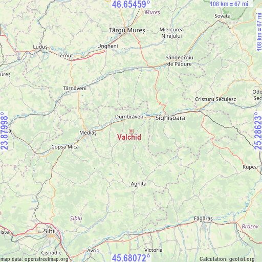
Valchid GPS coordinates[2]
46° 10' 11.316" North, 24° 34' 59.16" East
| Map corner | latitude | longitude |
|---|---|---|
| Upper-left | 46.65459°, | 23.87998° |
| Center: | 46.16981°, | 24.5831° |
| Lower-right: | 45.68072°, | 25.28623° |
| Map W x H: | 108.3×108.3 km | = 67.3×67.3mi |
| max Lat: | 48.23793° ⇑41% North |
| Valchid: | 46.16981° |
| min Lat: | ⇓59% South 43.65638° |
| min Long | Valchid | max Long |
| 20.31667° | 24.5831° | 29.65403° |
| W 40.9%⇐ | ⇒59.1% E |
Elevation
Elevation of Valchid is 364 m = 1194 ft, and this is 109.1 m = 358 ft above average elevation for this country.
| Max E: |
1278 m = 4193 ft | 23.5% |
| Valchid | 364 m 1194 ft | |
| Avg. | 254.9 m = 836 ft | |
Min E: |
-2 m = -7 ft | 76.5% |
See also: Romania elevation on elevation.city.
Geographical zone
Valchid is located in North temperate zone (between Tropic of Cancer and the Arctic Circle). Distance of this North polar circle is 2267.6 km =1409 mi to North.| Distance of | km | miles | from Valchid |
|---|---|---|---|
| North Pole | 4873.5 | 3028.3 | to North |
| Arctic Circle | 2267.6 | 1409 | to North |
| Tropic Cancer | 2527.7 | 1570.6 | to South |
| Equator | 5133.6 | 3189.9 | to South |


Nearby cities:
15 places around Valchid: (largest is in red/bold)
• Alma
9.3 km =5.8 mi,  301°
301°
• Aţel
9.2 km =5.7 mi,  256°
256°
• Biertan
6.5 km =4 mi,  231°
231°
• Brateiu
12.8 km =8 mi,  268°
268°
• Criș
9 km =5.6 mi,  108°
108°
• Daneş
10.4 km =6.5 mi,  59°
59°
• Dumbrăveni
7.2 km =4.5 mi,  349°
349°
• Hoghilag
7.5 km =4.7 mi,  20°
20°
• Laslea
7.3 km =4.5 mi,  44°
44°
• Mălâncrav
8.3 km =5.2 mi,  143°
143°
• Richiș
11.2 km =7 mi,  224°
224°
• Seleuș
11.8 km =7.3 mi,  46°
46°
• Viişoara
12.7 km =7.9 mi,  5°
5°
• Șaroș pe Târnave
4.2 km =2.6 mi,  322°
322°
• Șmig
12.3 km =7.6 mi, 300°
Sources, notices
• [Note1] Compared only with cities in Romania existing in our database
• [Src1] Map data: © OpenStreetMap contributors (CC-BY-SA)
• [Src2] Other city data from geonames.org with taken over terms of usage.
• [Src3] Geographical zone / Annual Mean Temperature by Robert A. Rohde @ Wikipedia
