Ungureni geodata
Ungureni (Prahova) is a populated place; located in Romania in Europe/Bucharest (GMT+3) time zone. With population of 976 people, there are 4364 cities with bigger population in this country. Compared to other cities in Romania, 72% of cities are located further ↑North; 59.4% of cities are located further ←West and 53.8% of cities have lower elevation than Ungureni. Note1


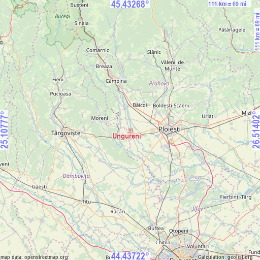
Ungureni GPS coordinates[2]
44° 56' 13.596" North, 25° 48' 39.204" East
| Map corner | latitude | longitude |
|---|---|---|
| Upper-left | 45.43268°, | 25.10777° |
| Center: | 44.93711°, | 25.81089° |
| Lower-right: | 44.43722°, | 26.51402° |
| Map W x H: | 110.7×110.7 km | = 68.8×68.8mi |
| max Lat: | 48.23793° ⇑72% North |
| Ungureni: | 44.93711° |
| min Lat: | ⇓28% South 43.65638° |
| min Long | Ungureni | max Long |
| 20.31667° | 25.81089° | 29.65403° |
| W 59.4%⇐ | ⇒40.6% E |
Elevation
Elevation of Ungureni is 232 m = 761 ft, and this is 22.9 m = 75 ft below average elevation for this country.
| Max E: |
1278 m = 4193 ft | 46.2% |
| Avg. | 254.9 m = 836 ft | |
| Ungureni | 232 m = 761 ft | |
Min E: |
-2 m = -7 ft | 53.8% |
See also: Romania elevation on elevation.city.
Geographical zone
Ungureni is located in North temperate zone (between Tropic of Cancer and the Arctic Circle). Distance of this Northern Tropic circle is 2390.6 km =1485.4 mi to South.| Distance of | km | miles | from Ungureni |
|---|---|---|---|
| North Pole | 5010.5 | 3113.4 | to North |
| Arctic Circle | 2404.6 | 1494.1 | to North |
| Tropic Cancer | 2390.6 | 1485.4 | to South |
| Equator | 4996.5 | 3104.7 | to South |


Nearby cities:
15 places around Ungureni: (largest is in red/bold)
• Ariceştii-Rahtivani
2.3 km =1.4 mi,  50°
50°
• Brătășanca
0.3 km =0.2 mi,  180°
180°
• Cătina
8.4 km =5.2 mi,  345°
345°
• Dițești
8.2 km =5.1 mi,  305°
305°
• Dărmăneşti
3.1 km =1.9 mi,  223°
223°
• Filipeştii de Pădure
8.5 km =5.3 mi,  325°
325°
• Filipeştii de Târg
5.6 km =3.5 mi,  337°
337°
• Minieri
6.5 km =4 mi,  322°
322°
• Măneşti
8.4 km =5.2 mi,  158°
158°
• Mărginenii de Jos
4.7 km =2.9 mi,  301°
301°
• Mărginenii de Sus
4.7 km =2.9 mi,  262°
262°
• Nedelea
3.9 km =2.4 mi,  6°
6°
• Stoenești
4 km =2.5 mi,  110°
110°
• Vlădeni
7.5 km =4.7 mi,  203°
203°
• Zalhanaua
4.2 km =2.6 mi, 157°
Sources, notices
• [Note1] Compared only with cities in Romania existing in our database
• [Src1] Map data: © OpenStreetMap contributors (CC-BY-SA)
• [Src2] Other city data from geonames.org with taken over terms of usage.
• [Src3] Geographical zone / Annual Mean Temperature by Robert A. Rohde @ Wikipedia
