Măneşti geodata
Măneşti (Prahova) is a seat of a second-order administrative division; located in Romania in Europe/Bucharest (GMT+3) time zone. With population of 7,186 people, there are 380 cities with bigger population in this country. Compared to other cities in Romania, 74.4% of cities are located further ↑North; 60.1% of cities are located further ←West and 55.6% of cities have higher elevation than Măneşti. Note1


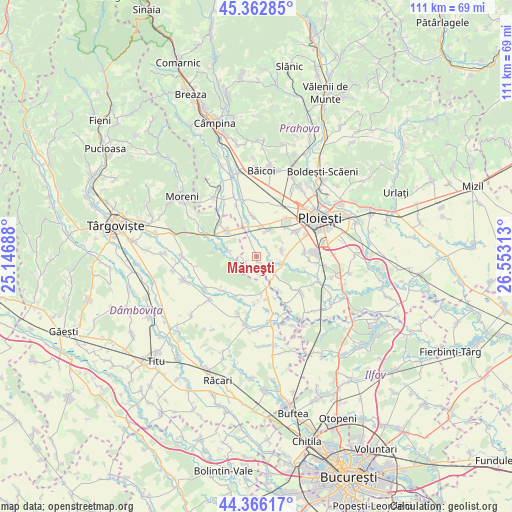
Măneşti GPS coordinates[2]
44° 52' 0.012" North, 25° 51' 0" East
| Map corner | latitude | longitude |
|---|---|---|
| Upper-left | 45.36285°, | 25.14688° |
| Center: | 44.86667°, | 25.85° |
| Lower-right: | 44.36617°, | 26.55313° |
| Map W x H: | 110.8×110.8 km | = 68.8×68.8mi |
| max Lat: | 48.23793° ⇑74.4% North |
| Măneşti: | 44.86667° |
| min Lat: | ⇓25.6% South 43.65638° |
| min Long | Măneşti | max Long |
| 20.31667° | 25.85° | 29.65403° |
| W 60.1%⇐ | ⇒39.9% E |
Elevation
Elevation of Măneşti is 184 m = 604 ft, and this is 70.9 m = 233 ft below average elevation for this country.
| Max E: |
1278 m = 4193 ft | 55.6% |
| Avg. | 254.9 m = 836 ft | |
| Măneşti | 184 m = 604 ft | |
Min E: |
-2 m = -7 ft | 44.4% |
See also: Romania elevation on elevation.city.
Geographical zone
Măneşti is located in North temperate zone (between Tropic of Cancer and the Arctic Circle). Distance of this Northern Tropic circle is 2382.8 km =1480.6 mi to South.| Distance of | km | miles | from Măneşti |
|---|---|---|---|
| North Pole | 5018.4 | 3118.3 | to North |
| Arctic Circle | 2412.5 | 1499.1 | to North |
| Tropic Cancer | 2382.8 | 1480.6 | to South |
| Equator | 4988.7 | 3099.8 | to South |


Nearby cities:
15 places around Măneşti: (largest is in red/bold)
• Brătășanca
8.1 km =5 mi,  337°
337°
• Băltița
3.2 km =2 mi,  176°
176°
• Coada Izvorului
2.7 km =1.7 mi,  248°
248°
• Cocorăștii Colț
5.3 km =3.3 mi,  132°
132°
• Cocorăștii Grind
3 km =1.9 mi,  136°
136°
• Dărmăneşti
7.6 km =4.7 mi,  316°
316°
• Finta Mare
8.4 km =5.2 mi,  208°
208°
• Frasinu
8.5 km =5.3 mi,  173°
173°
• Postârnacu
6.1 km =3.8 mi,  154°
154°
• Stoenești
6.4 km =4 mi,  6°
6°
• Stăncești
5.3 km =3.3 mi,  103°
103°
• Târgşoru Vechi
5.3 km =3.3 mi,  90°
90°
• Ungureni
8.4 km =5.2 mi, 338°
• Vlădeni
6.1 km =3.8 mi,  279°
279°
• Zalhanaua
4.2 km =2.6 mi, 339°
Sources, notices
• [Note1] Compared only with cities in Romania existing in our database
• [Src1] Map data: © OpenStreetMap contributors (CC-BY-SA)
• [Src2] Other city data from geonames.org with taken over terms of usage.
• [Src3] Geographical zone / Annual Mean Temperature by Robert A. Rohde @ Wikipedia
