Zalhanaua geodata
Zalhanaua (Prahova) is a populated place; located in Romania in Europe/Bucharest (GMT+3) time zone. With population of 986 people, there are 4337 cities with bigger population in this country. Compared to other cities in Romania, 72.9% of cities are located further ↑North; 59.8% of cities are located further ←West and 51.1% of cities have higher elevation than Zalhanaua. Note1


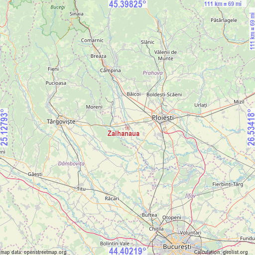
Zalhanaua GPS coordinates[2]
44° 54' 8.568" North, 25° 49' 51.78" East
| Map corner | latitude | longitude |
|---|---|---|
| Upper-left | 45.39825°, | 25.12793° |
| Center: | 44.90238°, | 25.83105° |
| Lower-right: | 44.40219°, | 26.53418° |
| Map W x H: | 110.8×110.8 km | = 68.8×68.8mi |
| max Lat: | 48.23793° ⇑72.9% North |
| Zalhanaua: | 44.90238° |
| min Lat: | ⇓27.1% South 43.65638° |
| min Long | Zalhanaua | max Long |
| 20.31667° | 25.83105° | 29.65403° |
| W 59.8%⇐ | ⇒40.2% E |
Elevation
Elevation of Zalhanaua is 206 m = 676 ft, and this is 48.9 m = 160 ft below average elevation for this country.
| Max E: |
1278 m = 4193 ft | 51.1% |
| Avg. | 254.9 m = 836 ft | |
| Zalhanaua | 206 m = 676 ft | |
Min E: |
-2 m = -7 ft | 48.9% |
See also: Romania elevation on elevation.city.
Geographical zone
Zalhanaua is located in North temperate zone (between Tropic of Cancer and the Arctic Circle). Distance of this Northern Tropic circle is 2386.8 km =1483.1 mi to South.| Distance of | km | miles | from Zalhanaua |
|---|---|---|---|
| North Pole | 5014.4 | 3115.8 | to North |
| Arctic Circle | 2408.5 | 1496.6 | to North |
| Tropic Cancer | 2386.8 | 1483.1 | to South |
| Equator | 4992.7 | 3102.3 | to South |


Nearby cities:
15 places around Zalhanaua: (largest is in red/bold)
• Ariceştii-Rahtivani
5.3 km =3.3 mi,  1°
1°
• Brătășanca
3.9 km =2.4 mi,  335°
335°
• Băltița
7.4 km =4.6 mi,  166°
166°
• Coada Izvorului
5.1 km =3.2 mi,  191°
191°
• Cocorăștii Grind
7.1 km =4.4 mi,  149°
149°
• Dărmăneşti
4.1 km =2.5 mi,  292°
292°
• Măneşti
4.2 km =2.6 mi,  159°
159°
• Mărginenii de Jos
8.4 km =5.2 mi,  318°
318°
• Mărginenii de Sus
7 km =4.3 mi,  297°
297°
• Nedelea
7.8 km =4.8 mi,  351°
351°
• Stoenești
3.3 km =2.1 mi,  41°
41°
• Stăncești
8.5 km =5.3 mi,  128°
128°
• Târgşoru Vechi
7.8 km =4.8 mi,  120°
120°
• Ungureni
4.2 km =2.6 mi, 337°
• Vlădeni
5.5 km =3.4 mi,  236°
236°
Sources, notices
• [Note1] Compared only with cities in Romania existing in our database
• [Src1] Map data: © OpenStreetMap contributors (CC-BY-SA)
• [Src2] Other city data from geonames.org with taken over terms of usage.
• [Src3] Geographical zone / Annual Mean Temperature by Robert A. Rohde @ Wikipedia
