Stoenești geodata
Stoenești (Prahova) is a populated place; located in Romania in Europe/Bucharest (GMT+3) time zone. With population of 1,351 people, there are 3427 cities with bigger population in this country. Compared to other cities in Romania, 72.4% of cities are located further ↑North; 60.4% of cities are located further ←West and 50.1% of cities have lower elevation than Stoenești. Note1


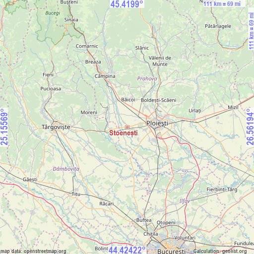
Stoenești GPS coordinates[2]
44° 55' 27.192" North, 25° 51' 31.716" East
| Map corner | latitude | longitude |
|---|---|---|
| Upper-left | 45.4199°, | 25.15569° |
| Center: | 44.92422°, | 25.85881° |
| Lower-right: | 44.42422°, | 26.56194° |
| Map W x H: | 110.7×110.7 km | = 68.8×68.8mi |
| max Lat: | 48.23793° ⇑72.4% North |
| Stoenești: | 44.92422° |
| min Lat: | ⇓27.6% South 43.65638° |
| min Long | Stoenești | max Long |
| 20.31667° | 25.85881° | 29.65403° |
| W 60.4%⇐ | ⇒39.6% E |
Elevation
Elevation of Stoenești is 212 m = 696 ft, and this is 42.9 m = 141 ft below average elevation for this country.
| Max E: |
1278 m = 4193 ft | 49.9% |
| Avg. | 254.9 m = 836 ft | |
| Stoenești | 212 m = 696 ft | |
Min E: |
-2 m = -7 ft | 50.1% |
See also: Romania elevation on elevation.city.
Geographical zone
Stoenești is located in North temperate zone (between Tropic of Cancer and the Arctic Circle). Distance of this Northern Tropic circle is 2389.2 km =1484.6 mi to South.| Distance of | km | miles | from Stoenești |
|---|---|---|---|
| North Pole | 5012 | 3114.3 | to North |
| Arctic Circle | 2406.1 | 1495.1 | to North |
| Tropic Cancer | 2389.2 | 1484.6 | to South |
| Equator | 4995.1 | 3103.8 | to South |


Nearby cities:
15 places around Stoenești: (largest is in red/bold)
• Ariceştii-Rahtivani
3.5 km =2.2 mi,  325°
325°
• Brătășanca
3.9 km =2.4 mi,  286°
286°
• Coada Izvorului
8.1 km =5 mi,  203°
203°
• Cocorăștii Grind
8.7 km =5.4 mi,  170°
170°
• Dărmăneşti
6 km =3.7 mi,  261°
261°
• Măneşti
6.4 km =4 mi,  186°
186°
• Mărginenii de Jos
8.7 km =5.4 mi,  296°
296°
• Mărginenii de Sus
8.4 km =5.2 mi,  275°
275°
• Nedelea
6.3 km =3.9 mi, 327°
• Strejnicu
7.3 km =4.5 mi,  96°
96°
• Stăncești
8.9 km =5.5 mi,  149°
149°
• Târgşoru Vechi
7.9 km =4.9 mi,  144°
144°
• Ungureni
4 km =2.5 mi, 290°
• Vlădeni
8.7 km =5.4 mi,  231°
231°
• Zalhanaua
3.3 km =2.1 mi,  221°
221°
Sources, notices
• [Note1] Compared only with cities in Romania existing in our database
• [Src1] Map data: © OpenStreetMap contributors (CC-BY-SA)
• [Src2] Other city data from geonames.org with taken over terms of usage.
• [Src3] Geographical zone / Annual Mean Temperature by Robert A. Rohde @ Wikipedia
