Haţeg geodata
Haţeg (Hunedoara) is a seat of a second-order administrative division; located in Romania in Europe/Bucharest (GMT+3) time zone. With population of 10,865 people, there are 189 cities with bigger population in this country. Compared to other cities in Romania, 53.4% of cities are located further ↑North; 85.2% of cities are located further →East and 72.8% of cities have lower elevation than Haţeg. Note1


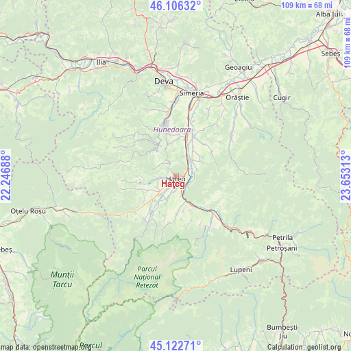
Haţeg GPS coordinates[2]
45° 37' 0.012" North, 22° 57' 0" East
| Map corner | latitude | longitude |
|---|---|---|
| Upper-left | 46.10632°, | 22.24688° |
| Center: | 45.61667°, | 22.95° |
| Lower-right: | 45.12271°, | 23.65313° |
| Map W x H: | 109.4×109.4 km | = 68×68mi |
| max Lat: | 48.23793° ⇑53.4% North |
| Haţeg: | 45.61667° |
| min Lat: | ⇓46.6% South 43.65638° |
| min Long | Haţeg | max Long |
| 20.31667° | 22.95° | 29.65403° |
| W 14.8%⇐ | ⇒85.2% E |
Elevation
Elevation of Haţeg is 339 m = 1112 ft, and this is 84.1 m = 276 ft above average elevation for this country.
| Max E: |
1278 m = 4193 ft | 27.2% |
| Haţeg | 339 m 1112 ft | |
| Avg. | 254.9 m = 836 ft | |
Min E: |
-2 m = -7 ft | 72.8% |
See also: Romania elevation on elevation.city.
Geographical zone
Haţeg is located in North temperate zone (between Tropic of Cancer and the Arctic Circle). Distance of this North polar circle is 2329.1 km =1447.2 mi to North.| Distance of | km | miles | from Haţeg |
|---|---|---|---|
| North Pole | 4935 | 3066.5 | to North |
| Arctic Circle | 2329.1 | 1447.2 | to North |
| Tropic Cancer | 2466.2 | 1532.4 | to South |
| Equator | 5072.1 | 3151.7 | to South |


Nearby cities:
15 places around Haţeg: (largest is in red/bold)
• Boşorod
12.7 km =7.9 mi,  54°
54°
• Bretea Română
7.2 km =4.5 mi, 46°
• Bucium-Orlea
3.9 km =2.4 mi,  160°
160°
• Cinciș-Cerna
10.5 km =6.5 mi,  334°
334°
• Călan
13.2 km =8.2 mi,  11°
11°
• Densuş
12.2 km =7.6 mi,  252°
252°
• General Berthelot
5.2 km =3.2 mi,  270°
270°
• Peșteana
12.3 km =7.6 mi,  232°
232°
• Păclișa
8.1 km =5 mi,  221°
221°
• Subcetate
4.1 km =2.5 mi,  112°
112°
• Sântămăria-Orlea
3.5 km =2.2 mi,  152°
152°
• Săcel
6.8 km =4.2 mi,  200°
200°
• Sălaşu de Sus
11.1 km =6.9 mi,  180°
180°
• Teliucu Inferior
12.3 km =7.6 mi,  335°
335°
• Toteşti
7.6 km =4.7 mi, 223°
Sources, notices
• [Note1] Compared only with cities in Romania existing in our database
• [Src1] Map data: © OpenStreetMap contributors (CC-BY-SA)
• [Src2] Other city data from geonames.org with taken over terms of usage.
• [Src3] Geographical zone / Annual Mean Temperature by Robert A. Rohde @ Wikipedia
