Ţigănaşi geodata
Ţigănaşi (Iaşi) is a seat of a second-order administrative division; located in Romania in Europe/Bucharest (GMT+3) time zone. With population of 4,283 people, there are 1055 cities with bigger population in this country. Compared to other cities in Romania, 87.3% of cities are located further ↓South; 90.5% of cities are located further ←West and 86.2% of cities have higher elevation than Ţigănaşi. Note1


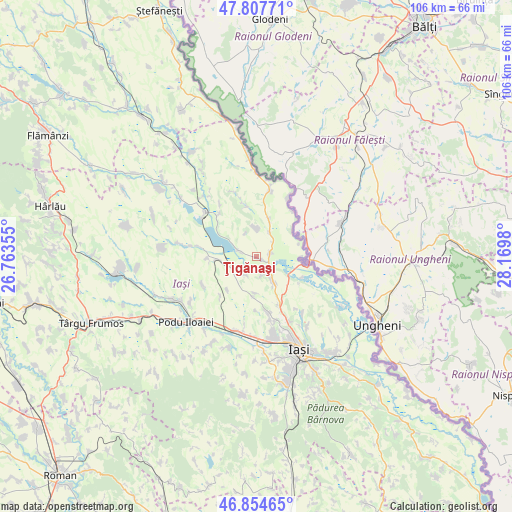
Ţigănaşi GPS coordinates[2]
47° 19' 59.988" North, 27° 28' 0.012" East
| Map corner | latitude | longitude |
|---|---|---|
| Upper-left | 47.80771°, | 26.76355° |
| Center: | 47.33333°, | 27.46667° |
| Lower-right: | 46.85465°, | 28.1698° |
| Map W x H: | 106×106 km | = 65.9×65.9mi |
| max Lat: | 48.23793° ⇑12.7% North |
| Ţigănaşi: | 47.33333° |
| min Lat: | ⇓87.3% South 43.65638° |
| min Long | Ţigănaşi | max Long |
| 20.31667° | 27.46667° | 29.65403° |
| W 90.5%⇐ | ⇒9.5% E |
Elevation
Elevation of Ţigănaşi is 74 m = 243 ft, and this is 180.9 m = 594 ft below average elevation for this country.
| Max E: |
1278 m = 4193 ft | 86.2% |
| Avg. | 254.9 m = 836 ft | |
| Ţigănaşi | 74 m = 243 ft | |
Min E: |
-2 m = -7 ft | 13.8% |
See also: Romania elevation on elevation.city.
Geographical zone
Ţigănaşi is located in North temperate zone (between Tropic of Cancer and the Arctic Circle). Distance of this North polar circle is 2138.2 km =1328.6 mi to North.| Distance of | km | miles | from Ţigănaşi |
|---|---|---|---|
| North Pole | 4744.1 | 2947.8 | to North |
| Arctic Circle | 2138.2 | 1328.6 | to North |
| Tropic Cancer | 2657.1 | 1651 | to South |
| Equator | 5263 | 3270.3 | to South |


Nearby cities:
15 places around Ţigănaşi: (largest is in red/bold)
• Avântu
11.2 km =7 mi,  221°
221°
• Bălteni
8.3 km =5.2 mi,  18°
18°
• Cârniceni
3 km =1.9 mi,  76°
76°
• Iepureni
4.4 km =2.7 mi,  212°
212°
• Larga-Jijia
6.2 km =3.9 mi,  257°
257°
• Mihail Kogălniceanu
4.2 km =2.6 mi,  291°
291°
• Movileni
9 km =5.6 mi, 258°
• Perieni
5.7 km =3.5 mi,  5°
5°
• Popricani
5.3 km =3.3 mi,  134°
134°
• Potângeni
9.8 km =6.1 mi,  267°
267°
• Probota
6.1 km =3.8 mi, 24°
• Rădeni
10.9 km =6.8 mi,  347°
347°
• Tăutești
11.1 km =6.9 mi,  180°
180°
• Victoria
10.4 km =6.5 mi,  122°
122°
• Vulturi
10.9 km =6.8 mi,  150°
150°
Sources, notices
• [Note1] Compared only with cities in Romania existing in our database
• [Src1] Map data: © OpenStreetMap contributors (CC-BY-SA)
• [Src2] Other city data from geonames.org with taken over terms of usage.
• [Src3] Geographical zone / Annual Mean Temperature by Robert A. Rohde @ Wikipedia
