Probota geodata
Probota (Iaşi) is a seat of a second-order administrative division; located in Romania in Europe/Bucharest (GMT+3) time zone. With population of 3,685 people, there are 1334 cities with bigger population in this country. Compared to other cities in Romania, 88.4% of cities are located further ↓South; 90.8% of cities are located further ←West and 85.4% of cities have higher elevation than Probota. Note1


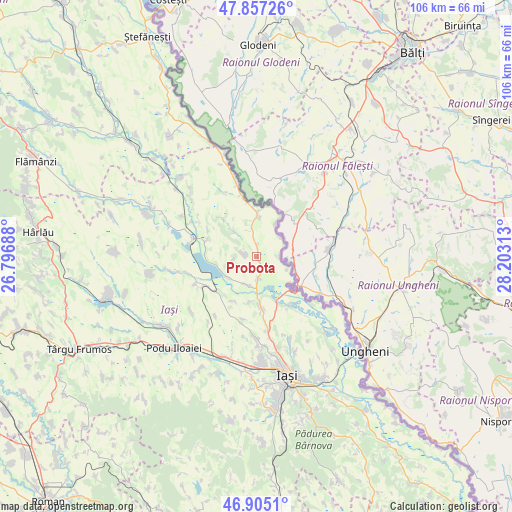
Probota GPS coordinates[2]
47° 22' 59.988" North, 27° 30' 0" East
| Map corner | latitude | longitude |
|---|---|---|
| Upper-left | 47.85726°, | 26.79688° |
| Center: | 47.38333°, | 27.5° |
| Lower-right: | 46.9051°, | 28.20313° |
| Map W x H: | 105.9×105.9 km | = 65.8×65.8mi |
| max Lat: | 48.23793° ⇑11.6% North |
| Probota: | 47.38333° |
| min Lat: | ⇓88.4% South 43.65638° |
| min Long | Probota | max Long |
| 20.31667° | 27.5° | 29.65403° |
| W 90.8%⇐ | ⇒9.2% E |
Elevation
Elevation of Probota is 77 m = 253 ft, and this is 177.9 m = 584 ft below average elevation for this country.
| Max E: |
1278 m = 4193 ft | 85.4% |
| Avg. | 254.9 m = 836 ft | |
| Probota | 77 m = 253 ft | |
Min E: |
-2 m = -7 ft | 14.6% |
See also: Romania elevation on elevation.city.
Geographical zone
Probota is located in North temperate zone (between Tropic of Cancer and the Arctic Circle). Distance of this North polar circle is 2132.6 km =1325.1 mi to North.| Distance of | km | miles | from Probota |
|---|---|---|---|
| North Pole | 4738.5 | 2944.4 | to North |
| Arctic Circle | 2132.6 | 1325.1 | to North |
| Tropic Cancer | 2662.6 | 1654.5 | to South |
| Equator | 5268.5 | 3273.7 | to South |


Nearby cities:
15 places around Probota: (largest is in red/bold)
• Borșa
10.8 km =6.7 mi,  289°
289°
• Bălteni
2.3 km =1.4 mi,  3°
3°
• Cârniceni
4.9 km =3 mi,  175°
175°
• Hermeziu
7.9 km =4.9 mi,  30°
30°
• Iepureni
10.4 km =6.5 mi,  207°
207°
• Larga-Jijia
11 km =6.8 mi,  230°
230°
• Mihail Kogălniceanu
7.6 km =4.7 mi,  237°
237°
• Perieni
1.9 km =1.2 mi,  274°
274°
• Popricani
9.4 km =5.8 mi,  172°
172°
• Roșcani
11 km =6.8 mi,  317°
317°
• Rădeni
7.1 km =4.4 mi, 316°
• Trifeşti
7.5 km =4.7 mi,  9°
9°
• Victoria
12.8 km =8 mi,  150°
150°
• Zaboloteni
10.3 km =6.4 mi,  359°
359°
• Ţigănaşi
6.1 km =3.8 mi,  204°
204°
Sources, notices
• [Note1] Compared only with cities in Romania existing in our database
• [Src1] Map data: © OpenStreetMap contributors (CC-BY-SA)
• [Src2] Other city data from geonames.org with taken over terms of usage.
• [Src3] Geographical zone / Annual Mean Temperature by Robert A. Rohde @ Wikipedia
