Tigveni geodata
Tigveni (Arges) is a populated place; located in Romania in Europe/Bucharest (GMT+3) time zone. With population of 555 people, there are 6541 cities with bigger population in this country. Compared to other cities in Romania, 78.7% of cities are located further ↑North; 50.6% of cities are located further →East and 52% of cities have lower elevation than Tigveni. Note1


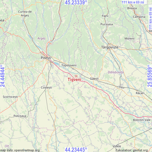
Tigveni GPS coordinates[2]
44° 44' 9.888" North, 25° 9' 9.216" East
| Map corner | latitude | longitude |
|---|---|---|
| Upper-left | 45.23339°, | 24.44944° |
| Center: | 44.73608°, | 25.15256° |
| Lower-right: | 44.23445°, | 25.85569° |
| Map W x H: | 111.1×111.1 km | = 69×69mi |
| max Lat: | 48.23793° ⇑78.7% North |
| Tigveni: | 44.73608° |
| min Lat: | ⇓21.3% South 43.65638° |
| min Long | Tigveni | max Long |
| 20.31667° | 25.15256° | 29.65403° |
| W 49.4%⇐ | ⇒50.6% E |
Elevation
Elevation of Tigveni is 222 m = 728 ft, and this is 32.9 m = 108 ft below average elevation for this country.
| Max E: |
1278 m = 4193 ft | 48% |
| Avg. | 254.9 m = 836 ft | |
| Tigveni | 222 m = 728 ft | |
Min E: |
-2 m = -7 ft | 52% |
See also: Romania elevation on elevation.city.
Geographical zone
Tigveni is located in North temperate zone (between Tropic of Cancer and the Arctic Circle). Distance of this Northern Tropic circle is 2368.3 km =1471.6 mi to South.| Distance of | km | miles | from Tigveni |
|---|---|---|---|
| North Pole | 5032.9 | 3127.3 | to North |
| Arctic Circle | 2427 | 1508.1 | to North |
| Tropic Cancer | 2368.3 | 1471.6 | to South |
| Equator | 4974.2 | 3090.8 | to South |


Nearby cities:
15 places around Tigveni: (largest is in red/bold)
• Ciulnița
5.7 km =3.5 mi,  1°
1°
• Crângurile de Sus
7.2 km =4.5 mi,  61°
61°
• Căteasca
6.4 km =4 mi,  301°
301°
• Furduești
3.9 km =2.4 mi,  250°
250°
• Glâmbocata-Deal
5.5 km =3.4 mi,  21°
21°
• Gruiu
6.5 km =4 mi,  269°
269°
• Leordeni
6 km =3.7 mi,  331°
331°
• Popeşti
7.6 km =4.7 mi, 296°
• Pătroaia Vale
6.3 km =3.9 mi,  99°
99°
• Pătuleni
1.1 km =0.7 mi,  112°
112°
• Răteşti
1.5 km =0.9 mi,  258°
258°
• Schitu Scoicești
8.9 km =5.5 mi,  358°
358°
• Siliștea
8.5 km =5.3 mi, 272°
• Teiu
8.8 km =5.5 mi,  208°
208°
• Valea Mare
8.3 km =5.2 mi,  50°
50°
Sources, notices
• [Note1] Compared only with cities in Romania existing in our database
• [Src1] Map data: © OpenStreetMap contributors (CC-BY-SA)
• [Src2] Other city data from geonames.org with taken over terms of usage.
• [Src3] Geographical zone / Annual Mean Temperature by Robert A. Rohde @ Wikipedia
