Siliștea geodata
Siliștea (Arges) is a populated place; located in Romania in Europe/Bucharest (GMT+3) time zone. With population of 559 people, there are 6514 cities with bigger population in this country. Compared to other cities in Romania, 78.7% of cities are located further ↑North; 52% of cities are located further →East and 57.1% of cities have lower elevation than Siliștea. Note1


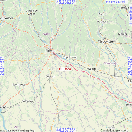
Siliștea GPS coordinates[2]
44° 44' 20.256" North, 25° 2' 40.884" East
| Map corner | latitude | longitude |
|---|---|---|
| Upper-left | 45.23625°, | 24.34157° |
| Center: | 44.73896°, | 25.04469° |
| Lower-right: | 44.23736°, | 25.74782° |
| Map W x H: | 111.1×111.1 km | = 69×69mi |
| max Lat: | 48.23793° ⇑78.7% North |
| Siliștea: | 44.73896° |
| min Lat: | ⇓21.3% South 43.65638° |
| min Long | Siliștea | max Long |
| 20.31667° | 25.04469° | 29.65403° |
| W 48%⇐ | ⇒52% E |
Elevation
Elevation of Siliștea is 248 m = 814 ft, and this is 6.9 m = 23 ft below average elevation for this country.
| Max E: |
1278 m = 4193 ft | 42.9% |
| Avg. | 254.9 m = 836 ft | |
| Siliștea | 248 m = 814 ft | |
Min E: |
-2 m = -7 ft | 57.1% |
See also: Romania elevation on elevation.city.
Geographical zone
Siliștea is located in North temperate zone (between Tropic of Cancer and the Arctic Circle). Distance of this Northern Tropic circle is 2368.6 km =1471.8 mi to South.| Distance of | km | miles | from Siliștea |
|---|---|---|---|
| North Pole | 5032.6 | 3127.1 | to North |
| Arctic Circle | 2426.7 | 1507.9 | to North |
| Tropic Cancer | 2368.6 | 1471.8 | to South |
| Equator | 4974.5 | 3091 | to South |


Nearby cities:
15 places around Siliștea: (largest is in red/bold)
• Cireșu
2.5 km =1.6 mi,  346°
346°
• Călineşti
8.7 km =5.4 mi,  2°
2°
• Căteasca
4.3 km =2.7 mi,  44°
44°
• Furduești
5.1 km =3.2 mi,  108°
108°
• Gruiu
2 km =1.2 mi,  101°
101°
• Leordeni
7.5 km =4.7 mi,  49°
49°
• Oarja
5.9 km =3.7 mi,  293°
293°
• Oarja Sat
6.4 km =4 mi,  295°
295°
• Popeşti
3.5 km =2.2 mi,  29°
29°
• Rociu
8.1 km =5 mi,  186°
186°
• Răteşti
7 km =4.3 mi, 95°
• Suseni
7.9 km =4.9 mi,  251°
251°
• Teiu
9.1 km =5.7 mi,  151°
151°
• Tigveni
8.5 km =5.3 mi,  92°
92°
• Șerbănești
7.6 km =4.7 mi,  212°
212°
Sources, notices
• [Note1] Compared only with cities in Romania existing in our database
• [Src1] Map data: © OpenStreetMap contributors (CC-BY-SA)
• [Src2] Other city data from geonames.org with taken over terms of usage.
• [Src3] Geographical zone / Annual Mean Temperature by Robert A. Rohde @ Wikipedia
