Ciulnița geodata
Ciulnița (Arges) is a populated place; located in Romania in Europe/Bucharest (GMT+3) time zone. With population of 1,049 people, there are 4128 cities with bigger population in this country. Compared to other cities in Romania, 77% of cities are located further ↑North; 50.6% of cities are located further →East and 52.6% of cities have lower elevation than Ciulnița. Note1


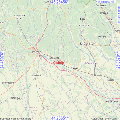
Ciulnița GPS coordinates[2]
44° 47' 15.684" North, 25° 9' 13.968" East
| Map corner | latitude | longitude |
|---|---|---|
| Upper-left | 45.28456°, | 24.45076° |
| Center: | 44.78769°, | 25.15388° |
| Lower-right: | 44.28651°, | 25.85701° |
| Map W x H: | 111×111 km | = 69×69mi |
| max Lat: | 48.23793° ⇑77% North |
| Ciulnița: | 44.78769° |
| min Lat: | ⇓23% South 43.65638° |
| min Long | Ciulnița | max Long |
| 20.31667° | 25.15388° | 29.65403° |
| W 49.4%⇐ | ⇒50.6% E |
Elevation
Elevation of Ciulnița is 225 m = 738 ft, and this is 29.9 m = 98 ft below average elevation for this country.
| Max E: |
1278 m = 4193 ft | 47.4% |
| Avg. | 254.9 m = 836 ft | |
| Ciulnița | 225 m = 738 ft | |
Min E: |
-2 m = -7 ft | 52.6% |
See also: Romania elevation on elevation.city.
Geographical zone
Ciulnița is located in North temperate zone (between Tropic of Cancer and the Arctic Circle). Distance of this Northern Tropic circle is 2374 km =1475.1 mi to South.| Distance of | km | miles | from Ciulnița |
|---|---|---|---|
| North Pole | 5027.1 | 3123.7 | to North |
| Arctic Circle | 2421.2 | 1504.5 | to North |
| Tropic Cancer | 2374 | 1475.1 | to South |
| Equator | 4979.9 | 3094.4 | to South |


Nearby cities:
15 places around Ciulnița: (largest is in red/bold)
• Crângurile de Sus
6.7 km =4.2 mi,  110°
110°
• Căteasca
6 km =3.7 mi,  247°
247°
• Furduești
8 km =5 mi,  208°
208°
• Glâmbocata-Deal
2 km =1.2 mi, 107°
• Glâmbocelu
5.9 km =3.7 mi,  349°
349°
• Hulubeşti
8.1 km =5 mi,  51°
51°
• Leordeni
3 km =1.9 mi,  260°
260°
• Popeşti
7.3 km =4.5 mi, 251°
• Pătuleni
6.2 km =3.9 mi,  171°
171°
• Răteşti
6.3 km =3.9 mi,  195°
195°
• Schitu Scoicești
3.2 km =2 mi,  355°
355°
• Tigveni
5.7 km =3.5 mi,  181°
181°
• Topoloveni
6.4 km =4 mi,  300°
300°
• Valea Caselor
7.5 km =4.7 mi,  79°
79°
• Valea Mare
6.3 km =3.9 mi,  94°
94°
Sources, notices
• [Note1] Compared only with cities in Romania existing in our database
• [Src1] Map data: © OpenStreetMap contributors (CC-BY-SA)
• [Src2] Other city data from geonames.org with taken over terms of usage.
• [Src3] Geographical zone / Annual Mean Temperature by Robert A. Rohde @ Wikipedia
