Niculiţel geodata
Niculiţel (Tulcea) is a seat of a second-order administrative division; located in Romania in Europe/Bucharest (GMT+3) time zone. With population of 4,690 people, there are 884 cities with bigger population in this country. Compared to other cities in Romania, 62.5% of cities are located further ↑North; 98.6% of cities are located further ←West and 82.5% of cities have higher elevation than Niculiţel. Note1


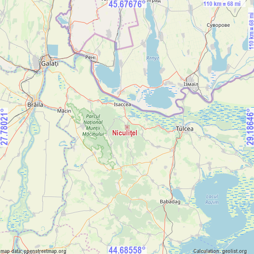
Niculiţel GPS coordinates[2]
45° 10' 59.988" North, 28° 28' 59.988" East
| Map corner | latitude | longitude |
|---|---|---|
| Upper-left | 45.67676°, | 27.78021° |
| Center: | 45.18333°, | 28.48333° |
| Lower-right: | 44.68558°, | 29.18646° |
| Map W x H: | 110.2×110.2 km | = 68.5×68.5mi |
| max Lat: | 48.23793° ⇑62.5% North |
| Niculiţel: | 45.18333° |
| min Lat: | ⇓37.5% South 43.65638° |
| min Long | Niculiţel | max Long |
| 20.31667° | 28.48333° | 29.65403° |
| W 98.6%⇐ | ⇒1.4% E |
Elevation
Elevation of Niculiţel is 86 m = 282 ft, and this is 168.9 m = 554 ft below average elevation for this country.
| Max E: |
1278 m = 4193 ft | 82.5% |
| Avg. | 254.9 m = 836 ft | |
| Niculiţel | 86 m = 282 ft | |
Min E: |
-2 m = -7 ft | 17.5% |
See also: Romania elevation on elevation.city.
Geographical zone
Niculiţel is located in North temperate zone (between Tropic of Cancer and the Arctic Circle). Distance of this North polar circle is 2377.3 km =1477.2 mi to North.| Distance of | km | miles | from Niculiţel |
|---|---|---|---|
| North Pole | 4983.1 | 3096.4 | to North |
| Arctic Circle | 2377.3 | 1477.2 | to North |
| Tropic Cancer | 2418 | 1502.5 | to South |
| Equator | 5023.9 | 3121.7 | to South |


Nearby cities:
15 places around Niculiţel: (largest is in red/bold)
• Cerna
17.2 km =10.7 mi,  229°
229°
• Frecăţei
17.1 km =10.6 mi,  122°
122°
• Hamcearca
11.8 km =7.3 mi, 230°
• Horia
18.7 km =11.6 mi,  188°
188°
• Isaccea
9.4 km =5.8 mi,  351°
351°
• Izvoarele
17.1 km =10.6 mi,  166°
166°
• Mineri
18.3 km =11.4 mi,  96°
96°
• Nalbant
18.1 km =11.2 mi,  144°
144°
• Parcheș
9.1 km =5.7 mi,  69°
69°
• Poșta
13.4 km =8.3 mi, 124°
• Rachelu
17 km =10.6 mi,  312°
312°
• Revărsarea
12.4 km =7.7 mi,  325°
325°
• Somova
14.4 km =8.9 mi,  90°
90°
• Telița
7.4 km =4.6 mi, 116°
• Valea Teilor
8 km =5 mi,  177°
177°
Sources, notices
• [Note1] Compared only with cities in Romania existing in our database
• [Src1] Map data: © OpenStreetMap contributors (CC-BY-SA)
• [Src2] Other city data from geonames.org with taken over terms of usage.
• [Src3] Geographical zone / Annual Mean Temperature by Robert A. Rohde @ Wikipedia
