Săcăşeni geodata
Săcăşeni (Satu Mare) is a seat of a second-order administrative division; located in Romania in Europe/Bucharest (GMT+3) time zone. With population of 1,319 people, there are 3481 cities with bigger population in this country. Compared to other cities in Romania, 90.6% of cities are located further ↓South; 88.4% of cities are located further →East and 63.7% of cities have higher elevation than Săcăşeni. Note1


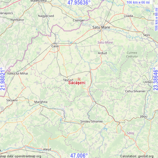
Săcăşeni GPS coordinates[2]
47° 28' 59.988" North, 22° 40' 59.988" East
| Map corner | latitude | longitude |
|---|---|---|
| Upper-left | 47.95636°, | 21.98021° |
| Center: | 47.48333°, | 22.68333° |
| Lower-right: | 47.006°, | 23.38646° |
| Map W x H: | 105.7×105.7 km | = 65.7×65.7mi |
| max Lat: | 48.23793° ⇑9.4% North |
| Săcăşeni: | 47.48333° |
| min Lat: | ⇓90.6% South 43.65638° |
| min Long | Săcăşeni | max Long |
| 20.31667° | 22.68333° | 29.65403° |
| W 11.6%⇐ | ⇒88.4% E |
Elevation
Elevation of Săcăşeni is 152 m = 499 ft, and this is 102.9 m = 338 ft below average elevation for this country.
| Max E: |
1278 m = 4193 ft | 63.7% |
| Avg. | 254.9 m = 836 ft | |
| Săcăşeni | 152 m = 499 ft | |
Min E: |
-2 m = -7 ft | 36.3% |
See also: Romania elevation on elevation.city.
Geographical zone
Săcăşeni is located in North temperate zone (between Tropic of Cancer and the Arctic Circle). Distance of this North polar circle is 2121.5 km =1318.2 mi to North.| Distance of | km | miles | from Săcăşeni |
|---|---|---|---|
| North Pole | 4727.4 | 2937.5 | to North |
| Arctic Circle | 2121.5 | 1318.2 | to North |
| Tropic Cancer | 2673.7 | 1661.4 | to South |
| Equator | 5279.7 | 3280.7 | to South |


Nearby cities:
15 places around Săcăşeni: (largest is in red/bold)
• Acâş
9.3 km =5.8 mi,  53°
53°
• Bobota
12.8 km =8 mi,  150°
150°
• Cehal
12.8 km =8 mi,  209°
209°
• Cehăluț
10.9 km =6.8 mi,  234°
234°
• Cig
6 km =3.7 mi,  326°
326°
• Dobra
10.9 km =6.8 mi,  83°
83°
• Eriu-Sâncrai
11.2 km =7 mi,  353°
353°
• Giorocuta
10.3 km =6.4 mi,  123°
123°
• Hurezu Mare
11.8 km =7.3 mi,  99°
99°
• Mihăieni
9.7 km =6 mi,  24°
24°
• Supuru de Jos
9 km =5.6 mi, 101°
• Sărăuad
4.4 km =2.7 mi,  264°
264°
• Tăşnad
7.5 km =4.7 mi,  270°
270°
• Unimăt
5.2 km =3.2 mi,  62°
62°
• Zalnoc
12.9 km =8 mi,  178°
178°
Sources, notices
• [Note1] Compared only with cities in Romania existing in our database
• [Src1] Map data: © OpenStreetMap contributors (CC-BY-SA)
• [Src2] Other city data from geonames.org with taken over terms of usage.
• [Src3] Geographical zone / Annual Mean Temperature by Robert A. Rohde @ Wikipedia
