Stoeneşti geodata
Stoeneşti (Arges) is a seat of a second-order administrative division; located in Romania in Europe/Bucharest (GMT+3) time zone. With population of 4,534 people, there are 938 cities with bigger population in this country. Compared to other cities in Romania, 60.3% of cities are located further ↑North; 50.5% of cities are located further →East and 94.9% of cities have lower elevation than Stoeneşti. Note1


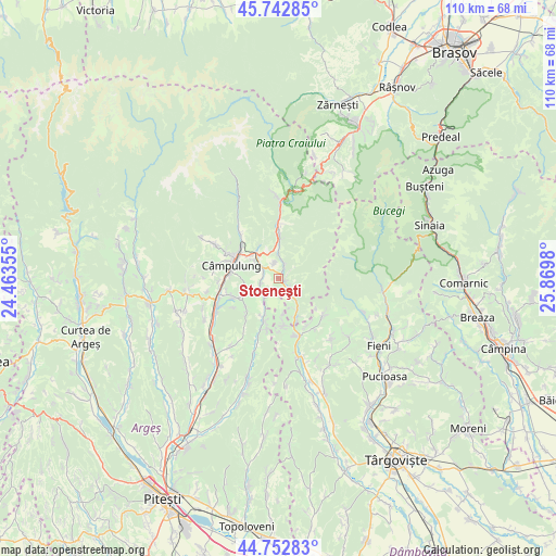
Stoeneşti GPS coordinates[2]
45° 15' 0" North, 25° 10' 0.012" East
| Map corner | latitude | longitude |
|---|---|---|
| Upper-left | 45.74285°, | 24.46355° |
| Center: | 45.25°, | 25.16667° |
| Lower-right: | 44.75283°, | 25.8698° |
| Map W x H: | 110.1×110.1 km | = 68.4×68.4mi |
| max Lat: | 48.23793° ⇑60.3% North |
| Stoeneşti: | 45.25° |
| min Lat: | ⇓39.7% South 43.65638° |
| min Long | Stoeneşti | max Long |
| 20.31667° | 25.16667° | 29.65403° |
| W 49.5%⇐ | ⇒50.5% E |
Elevation
Elevation of Stoeneşti is 626 m = 2054 ft, and this is 371.1 m = 1218 ft above average elevation for this country.
| Max E: |
1278 m = 4193 ft | 5.1% |
| Stoeneşti | 626 m 2054 ft | |
| Avg. | 254.9 m = 836 ft | |
Min E: |
-2 m = -7 ft | 94.9% |
See also: Romania elevation on elevation.city.
Geographical zone
Stoeneşti is located in North temperate zone (between Tropic of Cancer and the Arctic Circle). Distance of this North polar circle is 2369.8 km =1472.5 mi to North.| Distance of | km | miles | from Stoeneşti |
|---|---|---|---|
| North Pole | 4975.7 | 3091.8 | to North |
| Arctic Circle | 2369.8 | 1472.5 | to North |
| Tropic Cancer | 2425.4 | 1507.1 | to South |
| Equator | 5031.3 | 3126.3 | to South |


Nearby cities:
15 places around Stoeneşti: (largest is in red/bold)
• Boteni
8.4 km =5.2 mi,  207°
207°
• Bădeni
1.3 km =0.8 mi,  123°
123°
• Cetăţeni
5.7 km =3.5 mi,  166°
166°
• Cotenești
2.3 km =1.4 mi,  138°
138°
• Gura Pravăț
8.8 km =5.5 mi,  340°
340°
• Jugur
9 km =5.6 mi,  225°
225°
• Lunca
9.2 km =5.7 mi,  200°
200°
• Mățău
6.8 km =4.2 mi,  256°
256°
• Nămăești
7.4 km =4.6 mi,  325°
325°
• Piatra
3.2 km =2 mi, 341°
• Slobozia
3 km =1.9 mi,  21°
21°
• Suslănești
3.8 km =2.4 mi,  252°
252°
• Valea Bădenilor
2.6 km =1.6 mi,  56°
56°
• Valea Cetățuia
4.7 km =2.9 mi, 140°
• Valea Mare Pravăț
7.4 km =4.6 mi,  308°
308°
Sources, notices
• [Note1] Compared only with cities in Romania existing in our database
• [Src1] Map data: © OpenStreetMap contributors (CC-BY-SA)
• [Src2] Other city data from geonames.org with taken over terms of usage.
• [Src3] Geographical zone / Annual Mean Temperature by Robert A. Rohde @ Wikipedia
