Cotenești geodata
Cotenești (Arges) is a populated place; located in Romania in Europe/Bucharest (GMT+3) time zone. With population of 1,103 people, there are 3983 cities with bigger population in this country. Compared to other cities in Romania, 60.6% of cities are located further ↑North; 50.2% of cities are located further →East and 92.5% of cities have lower elevation than Cotenești. Note1


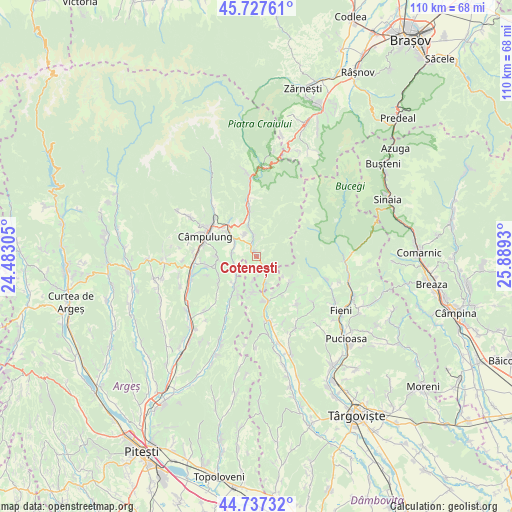
Cotenești GPS coordinates[2]
45° 14' 4.632" North, 25° 11' 10.212" East
| Map corner | latitude | longitude |
|---|---|---|
| Upper-left | 45.72761°, | 24.48305° |
| Center: | 45.23462°, | 25.18617° |
| Lower-right: | 44.73732°, | 25.8893° |
| Map W x H: | 110.1×110.1 km | = 68.4×68.4mi |
| max Lat: | 48.23793° ⇑60.6% North |
| Cotenești: | 45.23462° |
| min Lat: | ⇓39.4% South 43.65638° |
| min Long | Cotenești | max Long |
| 20.31667° | 25.18617° | 29.65403° |
| W 49.8%⇐ | ⇒50.2% E |
Elevation
Elevation of Cotenești is 559 m = 1834 ft, and this is 304.1 m = 998 ft above average elevation for this country.
| Max E: |
1278 m = 4193 ft | 7.5% |
| Cotenești | 559 m 1834 ft | |
| Avg. | 254.9 m = 836 ft | |
Min E: |
-2 m = -7 ft | 92.5% |
See also: Romania elevation on elevation.city.
Geographical zone
Cotenești is located in North temperate zone (between Tropic of Cancer and the Arctic Circle). Distance of this North polar circle is 2371.6 km =1473.6 mi to North.| Distance of | km | miles | from Cotenești |
|---|---|---|---|
| North Pole | 4977.4 | 3092.8 | to North |
| Arctic Circle | 2371.6 | 1473.6 | to North |
| Tropic Cancer | 2423.7 | 1506 | to South |
| Equator | 5029.6 | 3125.2 | to South |


Nearby cities:
15 places around Cotenești: (largest is in red/bold)
• Boteni
7.9 km =4.9 mi,  223°
223°
• Bădeni
1.1 km =0.7 mi,  334°
334°
• Cetăţeni
3.9 km =2.4 mi,  183°
183°
• Jugur
9.2 km =5.7 mi,  239°
239°
• Lunca
8.4 km =5.2 mi,  214°
214°
• Lăicăi
7.5 km =4.7 mi,  168°
168°
• Mățău
8.1 km =5 mi,  270°
270°
• Piatra
5.3 km =3.3 mi, 332°
• Pucheni
9.5 km =5.9 mi,  126°
126°
• Slobozia
4.5 km =2.8 mi,  354°
354°
• Stoeneşti
2.3 km =1.4 mi,  318°
318°
• Suslănești
5.2 km =3.2 mi,  275°
275°
• Valea Bădenilor
3.2 km =2 mi,  11°
11°
• Valea Cetățuia
2.4 km =1.5 mi,  142°
142°
• Văleni-Dâmbovița
7.6 km =4.7 mi, 181°
Sources, notices
• [Note1] Compared only with cities in Romania existing in our database
• [Src1] Map data: © OpenStreetMap contributors (CC-BY-SA)
• [Src2] Other city data from geonames.org with taken over terms of usage.
• [Src3] Geographical zone / Annual Mean Temperature by Robert A. Rohde @ Wikipedia
