Suslănești geodata
Suslănești (Arges) is a populated place; located in Romania in Europe/Bucharest (GMT+3) time zone. With population of 504 people, there are 6987 cities with bigger population in this country. Compared to other cities in Romania, 60.5% of cities are located further ↑North; 51.1% of cities are located further →East and 95.1% of cities have lower elevation than Suslănești. Note1


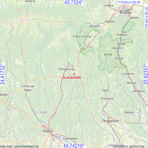
Suslănești GPS coordinates[2]
45° 14' 22.02" North, 25° 7' 13.584" East
| Map corner | latitude | longitude |
|---|---|---|
| Upper-left | 45.7324°, | 24.41732° |
| Center: | 45.23945°, | 25.12044° |
| Lower-right: | 44.74219°, | 25.82357° |
| Map W x H: | 110.1×110.1 km | = 68.4×68.4mi |
| max Lat: | 48.23793° ⇑60.5% North |
| Suslănești: | 45.23945° |
| min Lat: | ⇓39.5% South 43.65638° |
| min Long | Suslănești | max Long |
| 20.31667° | 25.12044° | 29.65403° |
| W 48.9%⇐ | ⇒51.1% E |
Elevation
Elevation of Suslănești is 631 m = 2070 ft, and this is 376.1 m = 1234 ft above average elevation for this country.
| Max E: |
1278 m = 4193 ft | 4.9% |
| Suslănești | 631 m 2070 ft | |
| Avg. | 254.9 m = 836 ft | |
Min E: |
-2 m = -7 ft | 95.1% |
See also: Romania elevation on elevation.city.
Geographical zone
Suslănești is located in North temperate zone (between Tropic of Cancer and the Arctic Circle). Distance of this North polar circle is 2371 km =1473.3 mi to North.| Distance of | km | miles | from Suslănești |
|---|---|---|---|
| North Pole | 4976.9 | 3092.5 | to North |
| Arctic Circle | 2371 | 1473.3 | to North |
| Tropic Cancer | 2424.2 | 1506.3 | to South |
| Equator | 5030.2 | 3125.6 | to South |


Nearby cities:
15 places around Suslănești: (largest is in red/bold)
• Boteni
6.2 km =3.9 mi,  182°
182°
• Bădeni
4.7 km =2.9 mi,  84°
84°
• Cetăţeni
6.6 km =4.1 mi,  131°
131°
• Cotenești
5.2 km =3.2 mi,  95°
95°
• Câmpulung
6.3 km =3.9 mi,  298°
298°
• Groșani
6.9 km =4.3 mi,  259°
259°
• Jugur
5.9 km =3.7 mi,  208°
208°
• Mățău
3 km =1.9 mi, 261°
• Piatra
4.9 km =3 mi,  32°
32°
• Poienari
6.1 km =3.8 mi,  245°
245°
• Slobozia
6.1 km =3.8 mi,  49°
49°
• Stoeneşti
3.8 km =2.4 mi,  72°
72°
• Valea Bădenilor
6.3 km =3.9 mi, 65°
• Valea Cetățuia
7.1 km =4.4 mi,  110°
110°
• Valea Mare Pravăț
6.2 km =3.9 mi,  339°
339°
Sources, notices
• [Note1] Compared only with cities in Romania existing in our database
• [Src1] Map data: © OpenStreetMap contributors (CC-BY-SA)
• [Src2] Other city data from geonames.org with taken over terms of usage.
• [Src3] Geographical zone / Annual Mean Temperature by Robert A. Rohde @ Wikipedia
