Piatra geodata
Piatra (Arges) is a populated place; located in Romania in Europe/Bucharest (GMT+3) time zone. With population of 584 people, there are 6334 cities with bigger population in this country. Compared to other cities in Romania, 59.6% of cities are located further ↑North; 50.5% of cities are located further →East and 98% of cities have lower elevation than Piatra. Note1


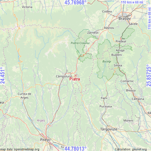
Piatra GPS coordinates[2]
45° 16' 37.416" North, 25° 9' 14.832" East
| Map corner | latitude | longitude |
|---|---|---|
| Upper-left | 45.76968°, | 24.451° |
| Center: | 45.27706°, | 25.15412° |
| Lower-right: | 44.78013°, | 25.85725° |
| Map W x H: | 110×110 km | = 68.4×68.4mi |
| max Lat: | 48.23793° ⇑59.6% North |
| Piatra: | 45.27706° |
| min Lat: | ⇓40.4% South 43.65638° |
| min Long | Piatra | max Long |
| 20.31667° | 25.15412° | 29.65403° |
| W 49.5%⇐ | ⇒50.5% E |
Elevation
Elevation of Piatra is 770 m = 2526 ft, and this is 515.1 m = 1690 ft above average elevation for this country.
| Max E: |
1278 m = 4193 ft | 2% |
| Piatra | 770 m 2526 ft | |
| Avg. | 254.9 m = 836 ft | |
Min E: |
-2 m = -7 ft | 98% |
See also: Romania elevation on elevation.city.
Geographical zone
Piatra is located in North temperate zone (between Tropic of Cancer and the Arctic Circle). Distance of this North polar circle is 2366.8 km =1470.7 mi to North.| Distance of | km | miles | from Piatra |
|---|---|---|---|
| North Pole | 4972.7 | 3089.9 | to North |
| Arctic Circle | 2366.8 | 1470.7 | to North |
| Tropic Cancer | 2428.4 | 1508.9 | to South |
| Equator | 5034.3 | 3128.2 | to South |


Nearby cities:
15 places around Piatra: (largest is in red/bold)
• Bădeni
4.2 km =2.6 mi,  151°
151°
• Cotenești
5.3 km =3.3 mi, 152°
• Câmpulung
8.2 km =5.1 mi,  261°
261°
• Dragoslavele
8 km =5 mi,  8°
8°
• Gura Pravăț
5.7 km =3.5 mi,  339°
339°
• Mățău
7.2 km =4.5 mi,  230°
230°
• Nămăești
4.4 km =2.7 mi,  314°
314°
• Slobozia
2.1 km =1.3 mi,  96°
96°
• Stoeneşti
3.2 km =2 mi,  161°
161°
• Suslănești
4.9 km =3 mi,  212°
212°
• Valea Bădenilor
3.5 km =2.2 mi,  116°
116°
• Valea Caselor
8.2 km =5.1 mi, 6°
• Valea Cetățuia
7.7 km =4.8 mi, 149°
• Valea Mare Pravăț
5.1 km =3.2 mi,  288°
288°
• Voinești
6.9 km =4.3 mi, 291°
Sources, notices
• [Note1] Compared only with cities in Romania existing in our database
• [Src1] Map data: © OpenStreetMap contributors (CC-BY-SA)
• [Src2] Other city data from geonames.org with taken over terms of usage.
• [Src3] Geographical zone / Annual Mean Temperature by Robert A. Rohde @ Wikipedia
