Condeești geodata
Condeești (Ialomiţa) is a populated place; located in Romania in Europe/Bucharest (GMT+3) time zone. With population of 2,284 people, there are 2336 cities with bigger population in this country. Compared to other cities in Romania, 82.1% of cities are located further ↑North; 76.5% of cities are located further ←West and 92.2% of cities have higher elevation than Condeești. Note1


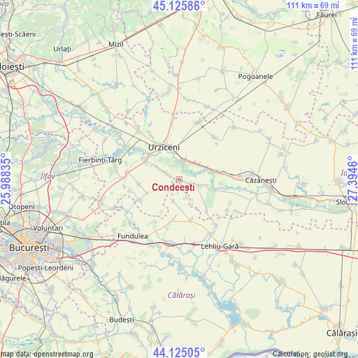
Condeești GPS coordinates[2]
44° 37' 39.396" North, 26° 41' 29.292" East
| Map corner | latitude | longitude |
|---|---|---|
| Upper-left | 45.12586°, | 25.98835° |
| Center: | 44.62761°, | 26.69147° |
| Lower-right: | 44.12505°, | 27.3946° |
| Map W x H: | 111.3×111.3 km | = 69.2×69.2mi |
| max Lat: | 48.23793° ⇑82.1% North |
| Condeești: | 44.62761° |
| min Lat: | ⇓17.9% South 43.65638° |
| min Long | Condeești | max Long |
| 20.31667° | 26.69147° | 29.65403° |
| W 76.5%⇐ | ⇒23.5% E |
Elevation
Elevation of Condeești is 48 m = 157 ft, and this is 206.9 m = 679 ft below average elevation for this country.
| Max E: |
1278 m = 4193 ft | 92.2% |
| Avg. | 254.9 m = 836 ft | |
| Condeești | 48 m = 157 ft | |
Min E: |
-2 m = -7 ft | 7.8% |
See also: Romania elevation on elevation.city.
Geographical zone
Condeești is located in North temperate zone (between Tropic of Cancer and the Arctic Circle). Distance of this Northern Tropic circle is 2356.2 km =1464.1 mi to South.| Distance of | km | miles | from Condeești |
|---|---|---|---|
| North Pole | 5044.9 | 3134.8 | to North |
| Arctic Circle | 2439 | 1515.5 | to North |
| Tropic Cancer | 2356.2 | 1464.1 | to South |
| Equator | 4962.1 | 3083.3 | to South |


Nearby cities:
15 places around Condeești: (largest is in red/bold)
• Alexeni
6.2 km =3.9 mi,  6°
6°
• Arțari
6.9 km =4.3 mi,  193°
193°
• Axintele
7.9 km =4.9 mi,  112°
112°
• Borănești
7.8 km =4.8 mi,  298°
298°
• Broșteni
6.6 km =4.1 mi,  42°
42°
• Butoiu
11.9 km =7.4 mi,  78°
78°
• Bărbulești
13.2 km =8.2 mi,  326°
326°
• Bărcăneşti
3.3 km =2.1 mi,  280°
280°
• Coşereni
11.7 km =7.3 mi, 302°
• Ileana
12.5 km =7.8 mi, 189°
• Ion Roată
7.4 km =4.6 mi,  53°
53°
• Manasia
8.3 km =5.2 mi,  346°
346°
• Roșiori
12.5 km =7.8 mi,  262°
262°
• Sfântu Gheorghe
11.5 km =7.1 mi, 77°
• Urziceni
10.9 km =6.8 mi,  335°
335°
Sources, notices
• [Note1] Compared only with cities in Romania existing in our database
• [Src1] Map data: © OpenStreetMap contributors (CC-BY-SA)
• [Src2] Other city data from geonames.org with taken over terms of usage.
• [Src3] Geographical zone / Annual Mean Temperature by Robert A. Rohde @ Wikipedia
