Slănic geodata
Slănic (Arges) is a populated place; located in Romania in Europe/Bucharest (GMT+3) time zone. With population of 1,114 people, there are 3945 cities with bigger population in this country. Compared to other cities in Romania, 60.8% of cities are located further ↑North; 54.1% of cities are located further →East and 92% of cities have lower elevation than Slănic. Note1


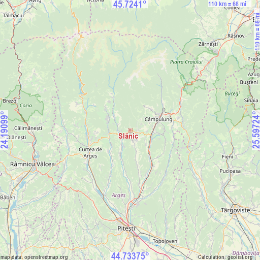
Slănic GPS coordinates[2]
45° 13' 51.888" North, 24° 53' 38.796" East
| Map corner | latitude | longitude |
|---|---|---|
| Upper-left | 45.7241°, | 24.19099° |
| Center: | 45.23108°, | 24.89411° |
| Lower-right: | 44.73375°, | 25.59724° |
| Map W x H: | 110.1×110.1 km | = 68.4×68.4mi |
| max Lat: | 48.23793° ⇑60.8% North |
| Slănic: | 45.23108° |
| min Lat: | ⇓39.2% South 43.65638° |
| min Long | Slănic | max Long |
| 20.31667° | 24.89411° | 29.65403° |
| W 45.9%⇐ | ⇒54.1% E |
Elevation
Elevation of Slănic is 548 m = 1798 ft, and this is 293.1 m = 962 ft above average elevation for this country.
| Max E: |
1278 m = 4193 ft | 8% |
| Slănic | 548 m 1798 ft | |
| Avg. | 254.9 m = 836 ft | |
Min E: |
-2 m = -7 ft | 92% |
See also: Romania elevation on elevation.city.
Geographical zone
Slănic is located in North temperate zone (between Tropic of Cancer and the Arctic Circle). Distance of this North polar circle is 2371.9 km =1473.8 mi to North.| Distance of | km | miles | from Slănic |
|---|---|---|---|
| North Pole | 4977.8 | 3093.1 | to North |
| Arctic Circle | 2371.9 | 1473.8 | to North |
| Tropic Cancer | 2423.3 | 1505.8 | to South |
| Equator | 5029.2 | 3125 | to South |


Nearby cities:
15 places around Slănic: (largest is in red/bold)
• Aninoasa
6.1 km =3.8 mi,  149°
149°
• Berevoeşti
1.8 km =1.1 mi,  81°
81°
• Bădești
7.1 km =4.4 mi,  201°
201°
• Capu Piscului
8.6 km =5.3 mi,  131°
131°
• Corbșori
6 km =3.7 mi,  294°
294°
• Cotești
7.4 km =4.6 mi,  120°
120°
• Domneşti
5.9 km =3.7 mi,  234°
234°
• Godeni
7 km =4.3 mi,  87°
87°
• Gămăcești
3.6 km =2.2 mi,  51°
51°
• Jgheaburi
8.9 km =5.5 mi,  308°
308°
• Pietroşani
6.3 km =3.9 mi,  213°
213°
• Robaia
9.1 km =5.7 mi,  259°
259°
• Schitu-Goleşti
9 km =5.6 mi,  112°
112°
• Stănești
4.6 km =2.9 mi,  267°
267°
• Valea Siliștii
4.7 km =2.9 mi,  167°
167°
Sources, notices
• [Note1] Compared only with cities in Romania existing in our database
• [Src1] Map data: © OpenStreetMap contributors (CC-BY-SA)
• [Src2] Other city data from geonames.org with taken over terms of usage.
• [Src3] Geographical zone / Annual Mean Temperature by Robert A. Rohde @ Wikipedia
