Godeni geodata
Godeni (Arges) is a seat of a second-order administrative division; located in Romania in Europe/Bucharest (GMT+3) time zone. With population of 3,333 people, there are 1534 cities with bigger population in this country. Compared to other cities in Romania, 60.7% of cities are located further ↑North; 52.8% of cities are located further →East and 92.2% of cities have lower elevation than Godeni. Note1


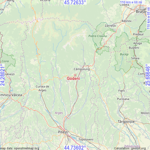
Godeni GPS coordinates[2]
45° 13' 59.988" North, 24° 58' 59.988" East
| Map corner | latitude | longitude |
|---|---|---|
| Upper-left | 45.72633°, | 24.28021° |
| Center: | 45.23333°, | 24.98333° |
| Lower-right: | 44.73602°, | 25.68646° |
| Map W x H: | 110.1×110.1 km | = 68.4×68.4mi |
| max Lat: | 48.23793° ⇑60.7% North |
| Godeni: | 45.23333° |
| min Lat: | ⇓39.3% South 43.65638° |
| min Long | Godeni | max Long |
| 20.31667° | 24.98333° | 29.65403° |
| W 47.2%⇐ | ⇒52.8% E |
Elevation
Elevation of Godeni is 552 m = 1811 ft, and this is 297.1 m = 975 ft above average elevation for this country.
| Max E: |
1278 m = 4193 ft | 7.8% |
| Godeni | 552 m 1811 ft | |
| Avg. | 254.9 m = 836 ft | |
Min E: |
-2 m = -7 ft | 92.2% |
See also: Romania elevation on elevation.city.
Geographical zone
Godeni is located in North temperate zone (between Tropic of Cancer and the Arctic Circle). Distance of this North polar circle is 2371.7 km =1473.7 mi to North.| Distance of | km | miles | from Godeni |
|---|---|---|---|
| North Pole | 4977.6 | 3092.9 | to North |
| Arctic Circle | 2371.7 | 1473.7 | to North |
| Tropic Cancer | 2423.6 | 1506 | to South |
| Equator | 5029.5 | 3125.2 | to South |


Nearby cities:
15 places around Godeni: (largest is in red/bold)
• Aninoasa
6.8 km =4.2 mi,  215°
215°
• Berevoeşti
5.2 km =3.2 mi,  270°
270°
• Bughea de Jos
3.9 km =2.4 mi,  19°
19°
• Bughea de Sus
8.2 km =5.1 mi,  28°
28°
• Capu Piscului
6 km =3.7 mi,  184°
184°
• Cotești
4 km =2.5 mi,  189°
189°
• Câmpulung
6.4 km =4 mi,  54°
54°
• Groșani
4 km =2.5 mi,  98°
98°
• Gămăcești
4.6 km =2.9 mi,  295°
295°
• Mățău
7.8 km =4.8 mi,  88°
88°
• Poienari
5.5 km =3.4 mi,  109°
109°
• Schitu-Goleşti
3.9 km =2.4 mi,  160°
160°
• Slănic
7 km =4.3 mi, 267°
• Valea Pechii
5.3 km =3.3 mi,  154°
154°
• Valea Siliștii
7.6 km =4.7 mi,  231°
231°
Sources, notices
• [Note1] Compared only with cities in Romania existing in our database
• [Src1] Map data: © OpenStreetMap contributors (CC-BY-SA)
• [Src2] Other city data from geonames.org with taken over terms of usage.
• [Src3] Geographical zone / Annual Mean Temperature by Robert A. Rohde @ Wikipedia
