Aninoasa geodata
Aninoasa (Arges) is a seat of a second-order administrative division; located in Romania in Europe/Bucharest (GMT+3) time zone. With population of 3,334 people, there are 1532 cities with bigger population in this country. Compared to other cities in Romania, 62.5% of cities are located further ↑North; 53.6% of cities are located further →East and 92.4% of cities have lower elevation than Aninoasa. Note1


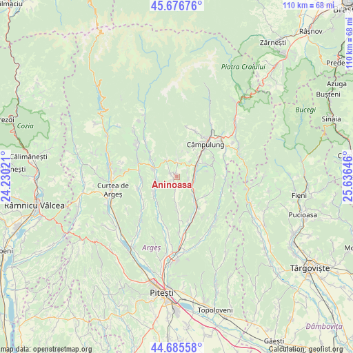
Aninoasa GPS coordinates[2]
45° 10' 59.988" North, 24° 55' 59.988" East
| Map corner | latitude | longitude |
|---|---|---|
| Upper-left | 45.67676°, | 24.23021° |
| Center: | 45.18333°, | 24.93333° |
| Lower-right: | 44.68558°, | 25.63646° |
| Map W x H: | 110.2×110.2 km | = 68.5×68.5mi |
| max Lat: | 48.23793° ⇑62.5% North |
| Aninoasa: | 45.18333° |
| min Lat: | ⇓37.5% South 43.65638° |
| min Long | Aninoasa | max Long |
| 20.31667° | 24.93333° | 29.65403° |
| W 46.4%⇐ | ⇒53.6% E |
Elevation
Elevation of Aninoasa is 557 m = 1827 ft, and this is 302.1 m = 991 ft above average elevation for this country.
| Max E: |
1278 m = 4193 ft | 7.6% |
| Aninoasa | 557 m 1827 ft | |
| Avg. | 254.9 m = 836 ft | |
Min E: |
-2 m = -7 ft | 92.4% |
See also: Romania elevation on elevation.city.
Geographical zone
Aninoasa is located in North temperate zone (between Tropic of Cancer and the Arctic Circle). Distance of this North polar circle is 2377.3 km =1477.2 mi to North.| Distance of | km | miles | from Aninoasa |
|---|---|---|---|
| North Pole | 4983.1 | 3096.4 | to North |
| Arctic Circle | 2377.3 | 1477.2 | to North |
| Tropic Cancer | 2418 | 1502.5 | to South |
| Equator | 5023.9 | 3121.7 | to South |


Nearby cities:
15 places around Aninoasa: (largest is in red/bold)
• Berevoeşti
5.7 km =3.5 mi,  346°
346°
• Bădești
5.8 km =3.6 mi,  257°
257°
• Capu Piscului
3.4 km =2.1 mi,  96°
96°
• Cotești
3.6 km =2.2 mi,  64°
64°
• Furnicoși
7 km =4.3 mi,  129°
129°
• Godeni
6.8 km =4.2 mi,  35°
35°
• Gămăcești
7.6 km =4.7 mi,  358°
358°
• Lăzărești
5.7 km =3.5 mi,  121°
121°
• Pietroşani
6.5 km =4 mi,  270°
270°
• Poienița
8 km =5 mi,  183°
183°
• Schitu-Goleşti
5.5 km =3.4 mi,  70°
70°
• Slănic
6.1 km =3.8 mi,  329°
329°
• Valea Pechii
6.3 km =3.9 mi,  82°
82°
• Valea Siliștii
2.2 km =1.4 mi,  290°
290°
• Vlădești
3.9 km =2.4 mi,  199°
199°
Sources, notices
• [Note1] Compared only with cities in Romania existing in our database
• [Src1] Map data: © OpenStreetMap contributors (CC-BY-SA)
• [Src2] Other city data from geonames.org with taken over terms of usage.
• [Src3] Geographical zone / Annual Mean Temperature by Robert A. Rohde @ Wikipedia
