Gămăcești geodata
Gămăcești (Arges) is a populated place; located in Romania in Europe/Bucharest (GMT+3) time zone. With population of 865 people, there are 4774 cities with bigger population in this country. Compared to other cities in Romania, 60.2% of cities are located further ↑North; 53.6% of cities are located further →East and 91.2% of cities have lower elevation than Gămăcești. Note1


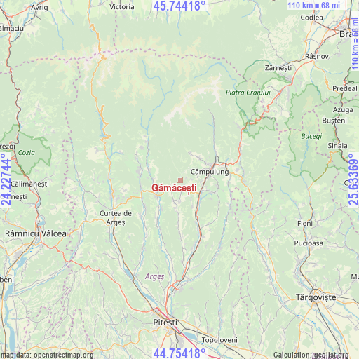
Gămăcești GPS coordinates[2]
45° 15' 4.824" North, 24° 55' 50.016" East
| Map corner | latitude | longitude |
|---|---|---|
| Upper-left | 45.74418°, | 24.22744° |
| Center: | 45.25134°, | 24.93056° |
| Lower-right: | 44.75418°, | 25.63369° |
| Map W x H: | 110.1×110.1 km | = 68.4×68.4mi |
| max Lat: | 48.23793° ⇑60.2% North |
| Gămăcești: | 45.25134° |
| min Lat: | ⇓39.8% South 43.65638° |
| min Long | Gămăcești | max Long |
| 20.31667° | 24.93056° | 29.65403° |
| W 46.4%⇐ | ⇒53.6% E |
Elevation
Elevation of Gămăcești is 532 m = 1745 ft, and this is 277.1 m = 909 ft above average elevation for this country.
| Max E: |
1278 m = 4193 ft | 8.8% |
| Gămăcești | 532 m 1745 ft | |
| Avg. | 254.9 m = 836 ft | |
Min E: |
-2 m = -7 ft | 91.2% |
See also: Romania elevation on elevation.city.
Geographical zone
Gămăcești is located in North temperate zone (between Tropic of Cancer and the Arctic Circle). Distance of this North polar circle is 2369.7 km =1472.5 mi to North.| Distance of | km | miles | from Gămăcești |
|---|---|---|---|
| North Pole | 4975.6 | 3091.7 | to North |
| Arctic Circle | 2369.7 | 1472.5 | to North |
| Tropic Cancer | 2425.6 | 1507.2 | to South |
| Equator | 5031.5 | 3126.4 | to South |


Nearby cities:
15 places around Gămăcești: (largest is in red/bold)
• Albeşti
8.9 km =5.5 mi,  43°
43°
• Aninoasa
7.6 km =4.7 mi,  178°
178°
• Berevoeşti
2.3 km =1.4 mi,  208°
208°
• Bughea de Jos
5.7 km =3.5 mi,  72°
72°
• Bughea de Sus
9.5 km =5.9 mi,  56°
56°
• Capu Piscului
8.7 km =5.4 mi,  155°
155°
• Corbșori
8.3 km =5.2 mi,  271°
271°
• Cotești
6.9 km =4.3 mi,  149°
149°
• Godeni
4.6 km =2.9 mi,  115°
115°
• Groșani
8.5 km =5.3 mi,  107°
107°
• Schitu-Goleşti
7.9 km =4.9 mi,  136°
136°
• Slănic
3.6 km =2.2 mi,  231°
231°
• Stănești
7.8 km =4.8 mi,  251°
251°
• Valea Pechii
9.3 km =5.8 mi, 136°
• Valea Siliștii
7 km =4.3 mi,  195°
195°
Sources, notices
• [Note1] Compared only with cities in Romania existing in our database
• [Src1] Map data: © OpenStreetMap contributors (CC-BY-SA)
• [Src2] Other city data from geonames.org with taken over terms of usage.
• [Src3] Geographical zone / Annual Mean Temperature by Robert A. Rohde @ Wikipedia
