Sânnicoară geodata
Sânnicoară (Cluj) is a populated place; located in Romania in Europe/Bucharest (GMT+3) time zone. With population of 1,309 people, there are 3503 cities with bigger population in this country. Compared to other cities in Romania, 73.9% of cities are located further ↓South; 73.8% of cities are located further →East and 68.1% of cities have lower elevation than Sânnicoară. Note1


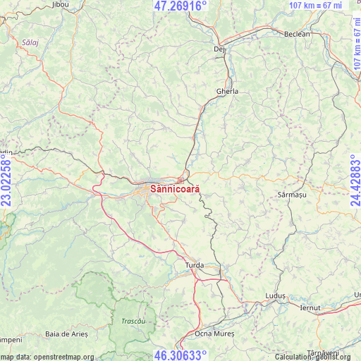
Sânnicoară GPS coordinates[2]
46° 47' 23.64" North, 23° 43' 32.52" East
| Map corner | latitude | longitude |
|---|---|---|
| Upper-left | 47.26916°, | 23.02258° |
| Center: | 46.7899°, | 23.7257° |
| Lower-right: | 46.30633°, | 24.42883° |
| Map W x H: | 107.1×107.1 km | = 66.5×66.5mi |
| max Lat: | 48.23793° ⇑26.1% North |
| Sânnicoară: | 46.7899° |
| min Lat: | ⇓73.9% South 43.65638° |
| min Long | Sânnicoară | max Long |
| 20.31667° | 23.7257° | 29.65403° |
| W 26.2%⇐ | ⇒73.8% E |
Elevation
Elevation of Sânnicoară is 307 m = 1007 ft, and this is 52.1 m = 171 ft above average elevation for this country.
| Max E: |
1278 m = 4193 ft | 31.9% |
| Sânnicoară | 307 m 1007 ft | |
| Avg. | 254.9 m = 836 ft | |
Min E: |
-2 m = -7 ft | 68.1% |
See also: Romania elevation on elevation.city.
Geographical zone
Sânnicoară is located in North temperate zone (between Tropic of Cancer and the Arctic Circle). Distance of this North polar circle is 2198.6 km =1366.1 mi to North.| Distance of | km | miles | from Sânnicoară |
|---|---|---|---|
| North Pole | 4804.5 | 2985.4 | to North |
| Arctic Circle | 2198.6 | 1366.1 | to North |
| Tropic Cancer | 2596.6 | 1613.5 | to South |
| Equator | 5202.5 | 3232.7 | to South |


Nearby cities:
15 places around Sânnicoară: (largest is in red/bold)
• Aiton
11.9 km =7.4 mi,  177°
177°
• Apahida
3.5 km =2.2 mi,  31°
31°
• Boju
9.8 km =6.1 mi,  154°
154°
• Cara
5.6 km =3.5 mi,  132°
132°
• Cluj-Napoca
9.9 km =6.2 mi,  254°
254°
• Cojocna
9.3 km =5.8 mi,  118°
118°
• Corpadea
7.8 km =4.8 mi,  88°
88°
• Dezmir
2.8 km =1.7 mi, 181°
• Feleacu
11.6 km =7.2 mi,  225°
225°
• Gheorghieni
8.9 km =5.5 mi,  198°
198°
• Gădălin
10.9 km =6.8 mi,  58°
58°
• Jucu de Mijloc
6.9 km =4.3 mi, 32°
• Pata
7.2 km =4.5 mi,  166°
166°
• Rediu
12.2 km =7.6 mi,  191°
191°
• Vâlcele
12.8 km =8 mi,  205°
205°
Sources, notices
• [Note1] Compared only with cities in Romania existing in our database
• [Src1] Map data: © OpenStreetMap contributors (CC-BY-SA)
• [Src2] Other city data from geonames.org with taken over terms of usage.
• [Src3] Geographical zone / Annual Mean Temperature by Robert A. Rohde @ Wikipedia
