Fărtăţeşti geodata
Fărtăţeşti (Vâlcea) is a seat of a second-order administrative division; located in Romania in Europe/Bucharest (GMT+3) time zone. With population of 4,561 people, there are 933 cities with bigger population in this country. Compared to other cities in Romania, 77.4% of cities are located further ↑North; 69.5% of cities are located further →East and 63% of cities have lower elevation than Fărtăţeşti. Note1


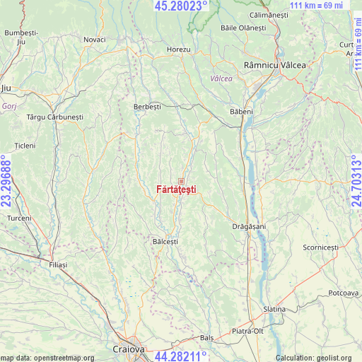
Fărtăţeşti GPS coordinates[2]
44° 46' 59.988" North, 24° 0' 0" East
| Map corner | latitude | longitude |
|---|---|---|
| Upper-left | 45.28023°, | 23.29688° |
| Center: | 44.78333°, | 24° |
| Lower-right: | 44.28211°, | 24.70313° |
| Map W x H: | 111×111 km | = 69×69mi |
| max Lat: | 48.23793° ⇑77.4% North |
| Fărtăţeşti: | 44.78333° |
| min Lat: | ⇓22.6% South 43.65638° |
| min Long | Fărtăţeşti | max Long |
| 20.31667° | 24° | 29.65403° |
| W 30.5%⇐ | ⇒69.5% E |
Elevation
Elevation of Fărtăţeşti is 279 m = 915 ft, and this is 24.1 m = 79 ft above average elevation for this country.
| Max E: |
1278 m = 4193 ft | 37% |
| Fărtăţeşti | 279 m 915 ft | |
| Avg. | 254.9 m = 836 ft | |
Min E: |
-2 m = -7 ft | 63% |
See also: Romania elevation on elevation.city.
Geographical zone
Fărtăţeşti is located in North temperate zone (between Tropic of Cancer and the Arctic Circle). Distance of this Northern Tropic circle is 2373.5 km =1474.8 mi to South.| Distance of | km | miles | from Fărtăţeşti |
|---|---|---|---|
| North Pole | 5027.6 | 3124 | to North |
| Arctic Circle | 2421.7 | 1504.8 | to North |
| Tropic Cancer | 2373.5 | 1474.8 | to South |
| Equator | 4979.4 | 3094.1 | to South |


Nearby cities:
15 places around Fărtăţeşti: (largest is in red/bold)
• Amărăşti
12 km =7.5 mi,  98°
98°
• Botorani
5.2 km =3.2 mi,  143°
143°
• Dozești
3.4 km =2.1 mi,  294°
294°
• Drăganu
7.9 km =4.9 mi,  178°
178°
• Guşoeni
10.8 km =6.7 mi,  121°
121°
• Lădeşti
11.8 km =7.3 mi,  19°
19°
• Mărgineni
9.8 km =6.1 mi, 177°
• Olteanca
9.2 km =5.7 mi,  70°
70°
• Oveselu
3.9 km =2.4 mi,  160°
160°
• Roşiile
10.7 km =6.6 mi,  330°
330°
• Stănești
5.4 km =3.4 mi,  46°
46°
• Sășcioara
10.4 km =6.5 mi,  280°
280°
• Tetoiu
7.6 km =4.7 mi,  240°
240°
• Zătreni
12 km =7.5 mi,  261°
261°
• Țepești
6.2 km =3.9 mi, 279°
Sources, notices
• [Note1] Compared only with cities in Romania existing in our database
• [Src1] Map data: © OpenStreetMap contributors (CC-BY-SA)
• [Src2] Other city data from geonames.org with taken over terms of usage.
• [Src3] Geographical zone / Annual Mean Temperature by Robert A. Rohde @ Wikipedia
