Șard geodata
Șard (Alba) is a populated place; located in Romania in Europe/Bucharest (GMT+3) time zone. With population of 1,861 people, there are 2747 cities with bigger population in this country. Compared to other cities in Romania, 58% of cities are located further ↓South; 76.4% of cities are located further →East and 57.8% of cities have lower elevation than Șard. Note1


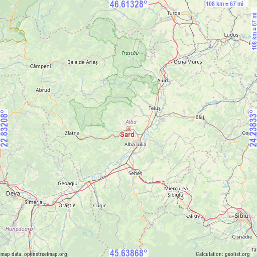
Șard GPS coordinates[2]
46° 7' 41.304" North, 23° 32' 6.72" East
| Map corner | latitude | longitude |
|---|---|---|
| Upper-left | 46.61328°, | 22.83208° |
| Center: | 46.12814°, | 23.5352° |
| Lower-right: | 45.63868°, | 24.23833° |
| Map W x H: | 108.4×108.4 km | = 67.4×67.4mi |
| max Lat: | 48.23793° ⇑42% North |
| Șard: | 46.12814° |
| min Lat: | ⇓58% South 43.65638° |
| min Long | Șard | max Long |
| 20.31667° | 23.5352° | 29.65403° |
| W 23.6%⇐ | ⇒76.4% E |
Elevation
Elevation of Șard is 252 m = 827 ft, and this is 2.9 m = 10 ft below average elevation for this country.
| Max E: |
1278 m = 4193 ft | 42.2% |
| Avg. | 254.9 m = 836 ft | |
| Șard | 252 m = 827 ft | |
Min E: |
-2 m = -7 ft | 57.8% |
See also: Romania elevation on elevation.city.
Geographical zone
Șard is located in North temperate zone (between Tropic of Cancer and the Arctic Circle). Distance of this North polar circle is 2272.2 km =1411.9 mi to North.| Distance of | km | miles | from Șard |
|---|---|---|---|
| North Pole | 4878.1 | 3031.1 | to North |
| Arctic Circle | 2272.2 | 1411.9 | to North |
| Tropic Cancer | 2523 | 1567.7 | to South |
| Equator | 5129 | 3187 | to South |


Nearby cities:
15 places around Șard: (largest is in red/bold)
• Alba Iulia
7.8 km =4.8 mi,  151°
151°
• Ampoița
6.7 km =4.2 mi,  259°
259°
• Bucerdea Vinoasă
3.9 km =2.4 mi,  353°
353°
• Bărăbanț
5 km =3.1 mi,  129°
129°
• Cricău
6.6 km =4.1 mi,  21°
21°
• Galda de Jos
8.8 km =5.5 mi,  45°
45°
• Ighiel
4.8 km =3 mi,  295°
295°
• Ighiu
2.8 km =1.7 mi,  329°
329°
• Micești
3.4 km =2.1 mi, 151°
• Oiejdea
8.3 km =5.2 mi,  66°
66°
• Pâclișa
8.8 km =5.5 mi,  189°
189°
• Sântimbru
8.9 km =5.5 mi,  86°
86°
• Totoi
9.5 km =5.9 mi,  98°
98°
• Tăuți
6.3 km =3.9 mi,  235°
235°
• Țelna
4.3 km =2.7 mi,  322°
322°
Sources, notices
• [Note1] Compared only with cities in Romania existing in our database
• [Src1] Map data: © OpenStreetMap contributors (CC-BY-SA)
• [Src2] Other city data from geonames.org with taken over terms of usage.
• [Src3] Geographical zone / Annual Mean Temperature by Robert A. Rohde @ Wikipedia
