Oiejdea geodata
Oiejdea (Alba) is a populated place; located in Romania in Europe/Bucharest (GMT+3) time zone. With population of 886 people, there are 4675 cities with bigger population in this country. Compared to other cities in Romania, 58.7% of cities are located further ↓South; 75% of cities are located further →East and 55.4% of cities have lower elevation than Oiejdea. Note1


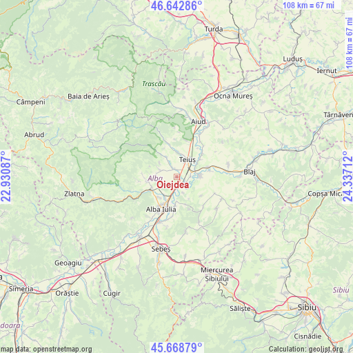
Oiejdea GPS coordinates[2]
46° 9' 28.728" North, 23° 38' 2.364" East
| Map corner | latitude | longitude |
|---|---|---|
| Upper-left | 46.64286°, | 22.93087° |
| Center: | 46.15798°, | 23.63399° |
| Lower-right: | 45.66879°, | 24.33712° |
| Map W x H: | 108.3×108.3 km | = 67.3×67.3mi |
| max Lat: | 48.23793° ⇑41.3% North |
| Oiejdea: | 46.15798° |
| min Lat: | ⇓58.7% South 43.65638° |
| min Long | Oiejdea | max Long |
| 20.31667° | 23.63399° | 29.65403° |
| W 25%⇐ | ⇒75% E |
Elevation
Elevation of Oiejdea is 240 m = 787 ft, and this is 14.9 m = 49 ft below average elevation for this country.
| Max E: |
1278 m = 4193 ft | 44.6% |
| Avg. | 254.9 m = 836 ft | |
| Oiejdea | 240 m = 787 ft | |
Min E: |
-2 m = -7 ft | 55.4% |
See also: Romania elevation on elevation.city.
Geographical zone
Oiejdea is located in North temperate zone (between Tropic of Cancer and the Arctic Circle). Distance of this North polar circle is 2268.9 km =1409.8 mi to North.| Distance of | km | miles | from Oiejdea |
|---|---|---|---|
| North Pole | 4874.8 | 3029.1 | to North |
| Arctic Circle | 2268.9 | 1409.8 | to North |
| Tropic Cancer | 2526.4 | 1569.8 | to South |
| Equator | 5132.3 | 3189.1 | to South |


Nearby cities:
15 places around Oiejdea: (largest is in red/bold)
• Benic
7 km =4.3 mi,  331°
331°
• Bucerdea Vinoasă
8.1 km =5 mi,  274°
274°
• Bărăbanț
7.5 km =4.7 mi,  210°
210°
• Cetea
9.6 km =6 mi,  337°
337°
• Cricău
5.9 km =3.7 mi,  298°
298°
• Galda de Jos
3.1 km =1.9 mi, 334°
• Henig
9.5 km =5.9 mi,  127°
127°
• Ighiu
9.1 km =5.7 mi,  264°
264°
• Micești
8.7 km =5.4 mi,  223°
223°
• Mihalţ
7.7 km =4.8 mi,  96°
96°
• Stremţ
6.5 km =4 mi,  359°
359°
• Sântimbru
3 km =1.9 mi,  155°
155°
• Teiuş
6 km =3.7 mi,  39°
39°
• Totoi
5.1 km =3.2 mi, 159°
• Șard
8.3 km =5.2 mi,  246°
246°
Sources, notices
• [Note1] Compared only with cities in Romania existing in our database
• [Src1] Map data: © OpenStreetMap contributors (CC-BY-SA)
• [Src2] Other city data from geonames.org with taken over terms of usage.
• [Src3] Geographical zone / Annual Mean Temperature by Robert A. Rohde @ Wikipedia
