Sântimbru geodata
Sântimbru (Alba) is a seat of a second-order administrative division; located in Romania in Europe/Bucharest (GMT+3) time zone. With population of 2,679 people, there are 1996 cities with bigger population in this country. Compared to other cities in Romania, 58% of cities are located further ↓South; 74.9% of cities are located further →East and 52% of cities have lower elevation than Sântimbru. Note1


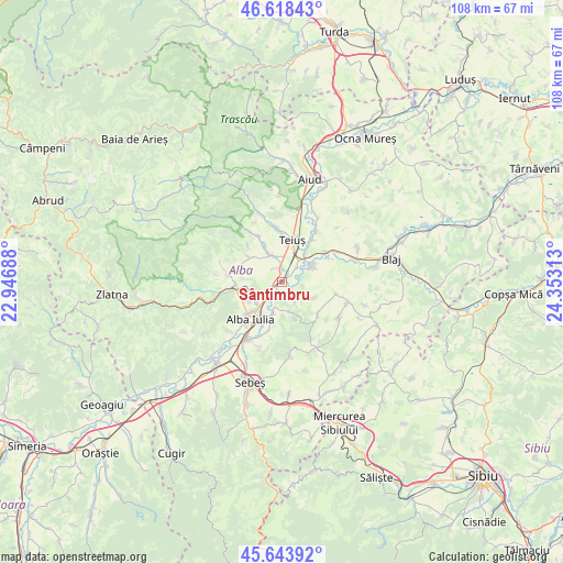
Sântimbru GPS coordinates[2]
46° 7' 59.988" North, 23° 39' 0" East
| Map corner | latitude | longitude |
|---|---|---|
| Upper-left | 46.61843°, | 22.94688° |
| Center: | 46.13333°, | 23.65° |
| Lower-right: | 45.64392°, | 24.35313° |
| Map W x H: | 108.4×108.4 km | = 67.4×67.4mi |
| max Lat: | 48.23793° ⇑42% North |
| Sântimbru: | 46.13333° |
| min Lat: | ⇓58% South 43.65638° |
| min Long | Sântimbru | max Long |
| 20.31667° | 23.65° | 29.65403° |
| W 25.1%⇐ | ⇒74.9% E |
Elevation
Elevation of Sântimbru is 222 m = 728 ft, and this is 32.9 m = 108 ft below average elevation for this country.
| Max E: |
1278 m = 4193 ft | 48% |
| Avg. | 254.9 m = 836 ft | |
| Sântimbru | 222 m = 728 ft | |
Min E: |
-2 m = -7 ft | 52% |
See also: Romania elevation on elevation.city.
Geographical zone
Sântimbru is located in North temperate zone (between Tropic of Cancer and the Arctic Circle). Distance of this North polar circle is 2271.6 km =1411.5 mi to North.| Distance of | km | miles | from Sântimbru |
|---|---|---|---|
| North Pole | 4877.5 | 3030.7 | to North |
| Arctic Circle | 2271.6 | 1411.5 | to North |
| Tropic Cancer | 2523.6 | 1568.1 | to South |
| Equator | 5129.5 | 3187.3 | to South |


Nearby cities:
15 places around Sântimbru: (largest is in red/bold)
• Alba Iulia
9 km =5.6 mi,  214°
214°
• Berghin
9.1 km =5.7 mi,  132°
132°
• Bărăbanț
6.3 km =3.9 mi,  232°
232°
• Ciugud
9.6 km =6 mi,  195°
195°
• Cricău
8.5 km =5.3 mi,  310°
310°
• Galda de Jos
6.1 km =3.8 mi,  335°
335°
• Henig
6.9 km =4.3 mi,  116°
116°
• Micești
8.1 km =5 mi,  243°
243°
• Mihalţ
6.7 km =4.2 mi,  73°
73°
• Oiejdea
3 km =1.9 mi, 335°
• Stremţ
9.4 km =5.8 mi,  352°
352°
• Teiuş
7.8 km =4.8 mi,  19°
19°
• Totoi
2.1 km =1.3 mi,  164°
164°
• Șard
8.9 km =5.5 mi,  266°
266°
• Șeușa
8.3 km =5.2 mi,  191°
191°
Sources, notices
• [Note1] Compared only with cities in Romania existing in our database
• [Src1] Map data: © OpenStreetMap contributors (CC-BY-SA)
• [Src2] Other city data from geonames.org with taken over terms of usage.
• [Src3] Geographical zone / Annual Mean Temperature by Robert A. Rohde @ Wikipedia
