Totoi geodata
Totoi (Alba) is a populated place; located in Romania in Europe/Bucharest (GMT+3) time zone. With population of 561 people, there are 6492 cities with bigger population in this country. Compared to other cities in Romania, 57.7% of cities are located further ↓South; 74.7% of cities are located further →East and 52.2% of cities have lower elevation than Totoi. Note1


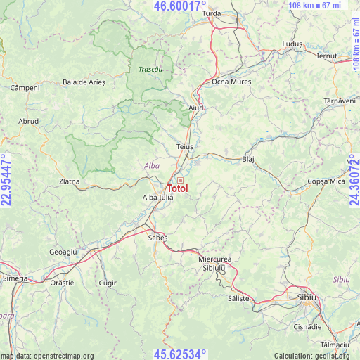
Totoi GPS coordinates[2]
46° 6' 53.676" North, 23° 39' 27.324" East
| Map corner | latitude | longitude |
|---|---|---|
| Upper-left | 46.60017°, | 22.95447° |
| Center: | 46.11491°, | 23.65759° |
| Lower-right: | 45.62534°, | 24.36072° |
| Map W x H: | 108.4×108.4 km | = 67.4×67.4mi |
| max Lat: | 48.23793° ⇑42.3% North |
| Totoi: | 46.11491° |
| min Lat: | ⇓57.7% South 43.65638° |
| min Long | Totoi | max Long |
| 20.31667° | 23.65759° | 29.65403° |
| W 25.3%⇐ | ⇒74.7% E |
Elevation
Elevation of Totoi is 223 m = 732 ft, and this is 31.9 m = 105 ft below average elevation for this country.
| Max E: |
1278 m = 4193 ft | 47.8% |
| Avg. | 254.9 m = 836 ft | |
| Totoi | 223 m = 732 ft | |
Min E: |
-2 m = -7 ft | 52.2% |
See also: Romania elevation on elevation.city.
Geographical zone
Totoi is located in North temperate zone (between Tropic of Cancer and the Arctic Circle). Distance of this North polar circle is 2273.7 km =1412.8 mi to North.| Distance of | km | miles | from Totoi |
|---|---|---|---|
| North Pole | 4879.6 | 3032 | to North |
| Arctic Circle | 2273.7 | 1412.8 | to North |
| Tropic Cancer | 2521.6 | 1566.8 | to South |
| Equator | 5127.5 | 3186.1 | to South |


Nearby cities:
15 places around Totoi: (largest is in red/bold)
• Alba Iulia
7.8 km =4.8 mi,  226°
226°
• Berghin
7.4 km =4.6 mi,  123°
123°
• Bărăbanț
5.9 km =3.7 mi,  252°
252°
• Ciugud
7.9 km =4.9 mi,  203°
203°
• Cricău
10.3 km =6.4 mi,  317°
317°
• Galda de Jos
8.2 km =5.1 mi,  337°
337°
• Ghirbom
10.3 km =6.4 mi,  150°
150°
• Henig
5.7 km =3.5 mi,  100°
100°
• Micești
8 km =5 mi,  259°
259°
• Mihalţ
7 km =4.3 mi,  56°
56°
• Oiejdea
5.1 km =3.2 mi, 339°
• Sântimbru
2.1 km =1.3 mi, 344°
• Teiuş
9.7 km =6 mi,  11°
11°
• Șard
9.5 km =5.9 mi,  278°
278°
• Șeușa
6.5 km =4 mi, 200°
Sources, notices
• [Note1] Compared only with cities in Romania existing in our database
• [Src1] Map data: © OpenStreetMap contributors (CC-BY-SA)
• [Src2] Other city data from geonames.org with taken over terms of usage.
• [Src3] Geographical zone / Annual Mean Temperature by Robert A. Rohde @ Wikipedia
