Boteni geodata
Boteni (Dâmboviţa) is a populated place; located in Romania in Europe/Bucharest (GMT+3) time zone. With population of 949 people, there are 4456 cities with bigger population in this country. Compared to other cities in Romania, 81.1% of cities are located further ↑North; 56.5% of cities are located further ←West and 63.2% of cities have higher elevation than Boteni. Note1


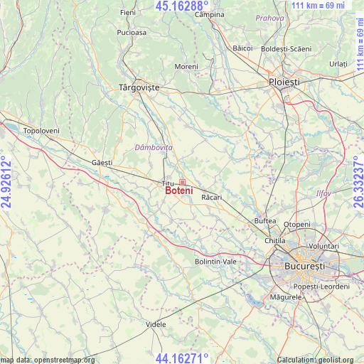
Boteni GPS coordinates[2]
44° 39' 53.82" North, 25° 37' 45.264" East
| Map corner | latitude | longitude |
|---|---|---|
| Upper-left | 45.16288°, | 24.92612° |
| Center: | 44.66495°, | 25.62924° |
| Lower-right: | 44.16271°, | 26.33237° |
| Map W x H: | 111.2×111.2 km | = 69.1×69.1mi |
| max Lat: | 48.23793° ⇑81.1% North |
| Boteni: | 44.66495° |
| min Lat: | ⇓18.9% South 43.65638° |
| min Long | Boteni | max Long |
| 20.31667° | 25.62924° | 29.65403° |
| W 56.5%⇐ | ⇒43.5% E |
Elevation
Elevation of Boteni is 154 m = 505 ft, and this is 100.9 m = 331 ft below average elevation for this country.
| Max E: |
1278 m = 4193 ft | 63.2% |
| Avg. | 254.9 m = 836 ft | |
| Boteni | 154 m = 505 ft | |
Min E: |
-2 m = -7 ft | 36.8% |
See also: Romania elevation on elevation.city.
Geographical zone
Boteni is located in North temperate zone (between Tropic of Cancer and the Arctic Circle). Distance of this Northern Tropic circle is 2360.4 km =1466.7 mi to South.| Distance of | km | miles | from Boteni |
|---|---|---|---|
| North Pole | 5040.8 | 3132.2 | to North |
| Arctic Circle | 2434.9 | 1513 | to North |
| Tropic Cancer | 2360.4 | 1466.7 | to South |
| Equator | 4966.3 | 3085.9 | to South |


Nearby cities:
15 places around Boteni: (largest is in red/bold)
• Bolovani
6.7 km =4.2 mi,  4°
4°
• Braniştea
4.2 km =2.6 mi,  299°
299°
• Bălteni
5.1 km =3.2 mi,  90°
90°
• Conțești
2.4 km =1.5 mi,  18°
18°
• Dâmbovicioara
6.1 km =3.8 mi,  281°
281°
• Fusea
7.5 km =4.7 mi,  267°
267°
• Hagioaica
7 km =4.3 mi, 273°
• Lunguleţu
5.6 km =3.5 mi,  162°
162°
• Mavrodin
7.2 km =4.5 mi,  104°
104°
• Odobeşti
7.3 km =4.5 mi,  222°
222°
• Podu Rizii
5.9 km =3.7 mi,  322°
322°
• Serdanu
4.2 km =2.6 mi,  177°
177°
• Sălcioara
6.8 km =4.2 mi,  327°
327°
• Sălcuța
4.5 km =2.8 mi,  238°
238°
• Titu
7.8 km =4.8 mi,  257°
257°
Sources, notices
• [Note1] Compared only with cities in Romania existing in our database
• [Src1] Map data: © OpenStreetMap contributors (CC-BY-SA)
• [Src2] Other city data from geonames.org with taken over terms of usage.
• [Src3] Geographical zone / Annual Mean Temperature by Robert A. Rohde @ Wikipedia
