Şag geodata
Şag (Timiş) is a seat of a second-order administrative division; located in Romania in Europe/Bucharest (GMT+3) time zone. With population of 4,461 people, there are 966 cities with bigger population in this country. Compared to other cities in Romania, 52.9% of cities are located further ↑North; 98.8% of cities are located further →East and 82.5% of cities have higher elevation than Şag. Note1


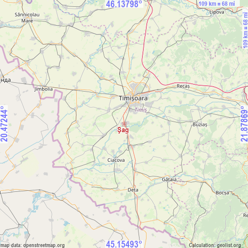
Şag GPS coordinates[2]
45° 38' 54.996" North, 21° 10' 32.016" East
| Map corner | latitude | longitude |
|---|---|---|
| Upper-left | 46.13798°, | 20.47244° |
| Center: | 45.64861°, | 21.17556° |
| Lower-right: | 45.15493°, | 21.87869° |
| Map W x H: | 109.3×109.3 km | = 67.9×67.9mi |
| max Lat: | 48.23793° ⇑52.9% North |
| Şag: | 45.64861° |
| min Lat: | ⇓47.1% South 43.65638° |
| min Long | Şag | max Long |
| 20.31667° | 21.17556° | 29.65403° |
| W 1.2%⇐ | ⇒98.8% E |
Elevation
Elevation of Şag is 86 m = 282 ft, and this is 168.9 m = 554 ft below average elevation for this country.
| Max E: |
1278 m = 4193 ft | 82.5% |
| Avg. | 254.9 m = 836 ft | |
| Şag | 86 m = 282 ft | |
Min E: |
-2 m = -7 ft | 17.5% |
See also: Romania elevation on elevation.city.
Geographical zone
Şag is located in North temperate zone (between Tropic of Cancer and the Arctic Circle). Distance of this North polar circle is 2325.5 km =1445 mi to North.| Distance of | km | miles | from Şag |
|---|---|---|---|
| North Pole | 4931.4 | 3064.2 | to North |
| Arctic Circle | 2325.5 | 1445 | to North |
| Tropic Cancer | 2469.7 | 1534.6 | to South |
| Equator | 5075.6 | 3153.8 | to South |


Nearby cities:
15 places around Şag: (largest is in red/bold)
• Chișoda
6.8 km =4.2 mi,  26°
26°
• Diniaș
13.2 km =8.2 mi,  271°
271°
• Giroc
6.9 km =4.3 mi,  42°
42°
• Jebel
10.8 km =6.7 mi,  164°
164°
• Obad
12.1 km =7.5 mi,  186°
186°
• Parța
3.6 km =2.2 mi,  232°
232°
• Peciu Nou
10.3 km =6.4 mi,  242°
242°
• Petroman
12.8 km =8 mi,  201°
201°
• Pădureni
6.3 km =3.9 mi,  148°
148°
• Sânmihaiu German
13.2 km =8.2 mi,  301°
301°
• Sânmihaiu Român
9.2 km =5.7 mi,  312°
312°
• Săcălaz
13.2 km =8.2 mi,  338°
338°
• Timişoara
12.3 km =7.6 mi,  18°
18°
• Urseni
11.5 km =7.1 mi,  64°
64°
• Utvin
8 km =5 mi,  333°
333°
Sources, notices
• [Note1] Compared only with cities in Romania existing in our database
• [Src1] Map data: © OpenStreetMap contributors (CC-BY-SA)
• [Src2] Other city data from geonames.org with taken over terms of usage.
• [Src3] Geographical zone / Annual Mean Temperature by Robert A. Rohde @ Wikipedia
