Parța geodata
Parța (Timiş) is a seat of a second-order administrative division; located in Romania in Europe/Bucharest (GMT+3) time zone. With population of 1,420 people, there are 3308 cities with bigger population in this country. Compared to other cities in Romania, 53.2% of cities are located further ↑North; 98.9% of cities are located further →East and 83.5% of cities have higher elevation than Parța. Note1


Parța GPS coordinates[2]
45° 37' 43.968" North, 21° 8' 19.572" East
| Map corner | latitude | longitude |
|---|---|---|
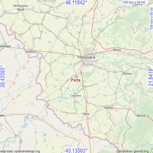
| Upper-left | 46.11842°, | 20.43565° |
| Center: | 45.62888°, | 21.13877° |
| Lower-right: | 45.13503°, | 21.8419° |
| Map W x H: | 109.3×109.3 km | = 67.9×67.9mi |
| max Lat: | 48.23793° ⇑53.2% North |
| Parța: | 45.62888° |
| min Lat: | ⇓46.8% South 43.65638° |
| min Long | Parța | max Long |
| 20.31667° | 21.13877° | 29.65403° |
| W 1.1%⇐ | ⇒98.9% E |
Elevation
Elevation of Parța is 83 m = 272 ft, and this is 171.9 m = 564 ft below average elevation for this country.
| Max E: |
1278 m = 4193 ft | 83.5% |
| Avg. | 254.9 m = 836 ft | |
| Parța | 83 m = 272 ft | |
Min E: |
-2 m = -7 ft | 16.5% |
See also: Romania elevation on elevation.city.
Geographical zone
Parța is located in North temperate zone (between Tropic of Cancer and the Arctic Circle). Distance of this North polar circle is 2327.7 km =1446.4 mi to North.| Distance of | km | miles | from Parța |
|---|---|---|---|
| North Pole | 4933.6 | 3065.6 | to North |
| Arctic Circle | 2327.7 | 1446.4 | to North |
| Tropic Cancer | 2467.5 | 1533.2 | to South |
| Equator | 5073.5 | 3152.5 | to South |


Nearby cities:
15 places around Parța: (largest is in red/bold)
• Cebza
10.2 km =6.3 mi,  213°
213°
• Chișoda
10.2 km =6.3 mi,  35°
35°
• Ciacova
13.5 km =8.4 mi,  183°
183°
• Diniaș
10.6 km =6.6 mi,  283°
283°
• Giroc
10.5 km =6.5 mi,  46°
46°
• Jebel
10 km =6.2 mi,  144°
144°
• Obad
9.9 km =6.2 mi,  171°
171°
• Peciu Nou
6.8 km =4.2 mi,  248°
248°
• Petroman
9.9 km =6.2 mi,  191°
191°
• Pădureni
6.9 km =4.3 mi,  117°
117°
• Sânmartinu Sârbesc
14.2 km =8.8 mi,  259°
259°
• Sânmihaiu German
12.4 km =7.7 mi,  317°
317°
• Sânmihaiu Român
9.3 km =5.8 mi,  335°
335°
• Utvin
9.4 km =5.8 mi,  355°
355°
• Şag
3.6 km =2.2 mi, 52°
Sources, notices
• [Note1] Compared only with cities in Romania existing in our database
• [Src1] Map data: © OpenStreetMap contributors (CC-BY-SA)
• [Src2] Other city data from geonames.org with taken over terms of usage.
• [Src3] Geographical zone / Annual Mean Temperature by Robert A. Rohde @ Wikipedia
