Pădureni geodata
Pădureni (Timiş) is a seat of a second-order administrative division; located in Romania in Europe/Bucharest (GMT+3) time zone. With population of 1,566 people, there are 3093 cities with bigger population in this country. Compared to other cities in Romania, 53.5% of cities are located further ↑North; 98.7% of cities are located further →East and 83.5% of cities have higher elevation than Pădureni. Note1


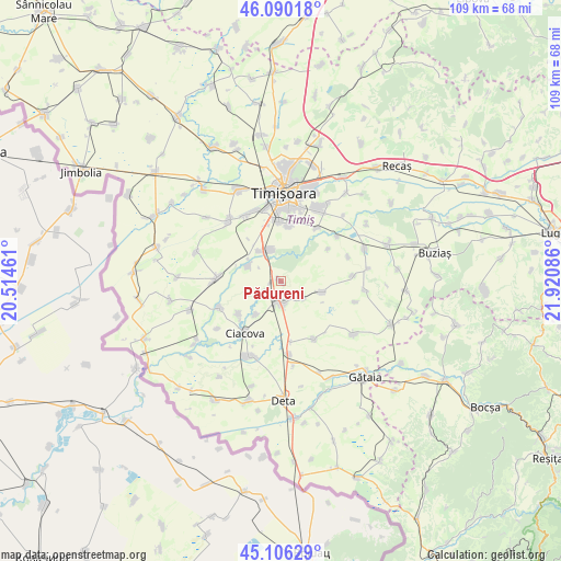
Pădureni GPS coordinates[2]
45° 36' 1.404" North, 21° 13' 3.828" East
| Map corner | latitude | longitude |
|---|---|---|
| Upper-left | 46.09018°, | 20.51461° |
| Center: | 45.60039°, | 21.21773° |
| Lower-right: | 45.10629°, | 21.92086° |
| Map W x H: | 109.4×109.4 km | = 68×68mi |
| max Lat: | 48.23793° ⇑53.5% North |
| Pădureni: | 45.60039° |
| min Lat: | ⇓46.5% South 43.65638° |
| min Long | Pădureni | max Long |
| 20.31667° | 21.21773° | 29.65403° |
| W 1.3%⇐ | ⇒98.7% E |
Elevation
Elevation of Pădureni is 83 m = 272 ft, and this is 171.9 m = 564 ft below average elevation for this country.
| Max E: |
1278 m = 4193 ft | 83.5% |
| Avg. | 254.9 m = 836 ft | |
| Pădureni | 83 m = 272 ft | |
Min E: |
-2 m = -7 ft | 16.5% |
See also: Romania elevation on elevation.city.
Geographical zone
Pădureni is located in North temperate zone (between Tropic of Cancer and the Arctic Circle). Distance of this North polar circle is 2330.9 km =1448.4 mi to North.| Distance of | km | miles | from Pădureni |
|---|---|---|---|
| North Pole | 4936.8 | 3067.6 | to North |
| Arctic Circle | 2330.9 | 1448.4 | to North |
| Tropic Cancer | 2464.4 | 1531.3 | to South |
| Equator | 5070.3 | 3150.5 | to South |


Nearby cities:
15 places around Pădureni: (largest is in red/bold)
• Cebza
12.9 km =8 mi,  245°
245°
• Chișoda
11.5 km =7.1 mi,  358°
358°
• Ciacova
12.4 km =7.7 mi,  214°
214°
• Giroc
10.5 km =6.5 mi,  7°
7°
• Jebel
5 km =3.1 mi,  183°
183°
• Liebling
8.5 km =5.3 mi,  107°
107°
• Obad
8.2 km =5.1 mi,  215°
215°
• Parța
6.9 km =4.3 mi,  297°
297°
• Peciu Nou
12.5 km =7.8 mi,  273°
273°
• Petroman
10.4 km =6.5 mi,  230°
230°
• Uliuc
14 km =8.7 mi,  52°
52°
• Urseni
12.5 km =7.8 mi,  34°
34°
• Utvin
14.3 km =8.9 mi,  331°
331°
• Voiteg
14.7 km =9.1 mi,  173°
173°
• Şag
6.3 km =3.9 mi, 328°
Sources, notices
• [Note1] Compared only with cities in Romania existing in our database
• [Src1] Map data: © OpenStreetMap contributors (CC-BY-SA)
• [Src2] Other city data from geonames.org with taken over terms of usage.
• [Src3] Geographical zone / Annual Mean Temperature by Robert A. Rohde @ Wikipedia
