Dobra geodata
Dobra (Satu Mare) is a populated place; located in Romania in Europe/Bucharest (GMT+3) time zone. With population of 1,330 people, there are 3464 cities with bigger population in this country. Compared to other cities in Romania, 90.9% of cities are located further ↓South; 86.8% of cities are located further →East and 66.3% of cities have higher elevation than Dobra. Note1


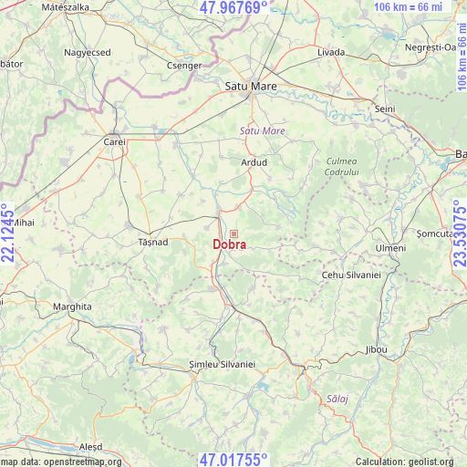
Dobra GPS coordinates[2]
47° 29' 41.172" North, 22° 49' 39.432" East
| Map corner | latitude | longitude |
|---|---|---|
| Upper-left | 47.96769°, | 22.1245° |
| Center: | 47.49477°, | 22.82762° |
| Lower-right: | 47.01755°, | 23.53075° |
| Map W x H: | 105.6×105.6 km | = 65.6×65.6mi |
| max Lat: | 48.23793° ⇑9.1% North |
| Dobra: | 47.49477° |
| min Lat: | ⇓90.9% South 43.65638° |
| min Long | Dobra | max Long |
| 20.31667° | 22.82762° | 29.65403° |
| W 13.2%⇐ | ⇒86.8% E |
Elevation
Elevation of Dobra is 142 m = 466 ft, and this is 112.9 m = 370 ft below average elevation for this country.
| Max E: |
1278 m = 4193 ft | 66.3% |
| Avg. | 254.9 m = 836 ft | |
| Dobra | 142 m = 466 ft | |
Min E: |
-2 m = -7 ft | 33.7% |
See also: Romania elevation on elevation.city.
Geographical zone
Dobra is located in North temperate zone (between Tropic of Cancer and the Arctic Circle). Distance of this North polar circle is 2120.3 km =1317.5 mi to North.| Distance of | km | miles | from Dobra |
|---|---|---|---|
| North Pole | 4726.1 | 2936.7 | to North |
| Arctic Circle | 2120.3 | 1317.5 | to North |
| Tropic Cancer | 2675 | 1662.2 | to South |
| Equator | 5280.9 | 3281.4 | to South |


Nearby cities:
15 places around Dobra: (largest is in red/bold)
• Acâş
5.4 km =3.4 mi,  322°
322°
• Babța
9.6 km =6 mi,  115°
115°
• Beltiug
6.4 km =4 mi,  15°
15°
• Bogdand
11.8 km =7.3 mi,  137°
137°
• Corund
8.7 km =5.4 mi,  158°
158°
• Derșida
12 km =7.5 mi,  189°
189°
• Ghirișa
11.5 km =7.1 mi,  347°
347°
• Giorocuta
7.3 km =4.5 mi,  197°
197°
• Hurezu Mare
3.4 km =2.1 mi,  166°
166°
• Mihăieni
10.2 km =6.3 mi, 317°
• Rătești
10.6 km =6.6 mi, 23°
• Stâna
10.4 km =6.5 mi,  82°
82°
• Supuru de Jos
3.8 km =2.4 mi,  213°
213°
• Săcăşeni
10.9 km =6.8 mi,  263°
263°
• Unimăt
6.3 km =3.9 mi,  280°
280°
Sources, notices
• [Note1] Compared only with cities in Romania existing in our database
• [Src1] Map data: © OpenStreetMap contributors (CC-BY-SA)
• [Src2] Other city data from geonames.org with taken over terms of usage.
• [Src3] Geographical zone / Annual Mean Temperature by Robert A. Rohde @ Wikipedia
