Rociu geodata
Rociu (Arges) is a seat of a second-order administrative division; located in Romania in Europe/Bucharest (GMT+3) time zone. With population of 2,980 people, there are 1783 cities with bigger population in this country. Compared to other cities in Romania, 81.1% of cities are located further ↑North; 52.2% of cities are located further →East and 50.5% of cities have lower elevation than Rociu. Note1


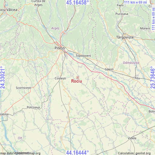
Rociu GPS coordinates[2]
44° 40' 0.012" North, 25° 1' 59.988" East
| Map corner | latitude | longitude |
|---|---|---|
| Upper-left | 45.16458°, | 24.33021° |
| Center: | 44.66667°, | 25.03333° |
| Lower-right: | 44.16444°, | 25.73646° |
| Map W x H: | 111.2×111.2 km | = 69.1×69.1mi |
| max Lat: | 48.23793° ⇑81.1% North |
| Rociu: | 44.66667° |
| min Lat: | ⇓18.9% South 43.65638° |
| min Long | Rociu | max Long |
| 20.31667° | 25.03333° | 29.65403° |
| W 47.8%⇐ | ⇒52.2% E |
Elevation
Elevation of Rociu is 214 m = 702 ft, and this is 40.9 m = 134 ft below average elevation for this country.
| Max E: |
1278 m = 4193 ft | 49.5% |
| Avg. | 254.9 m = 836 ft | |
| Rociu | 214 m = 702 ft | |
Min E: |
-2 m = -7 ft | 50.5% |
See also: Romania elevation on elevation.city.
Geographical zone
Rociu is located in North temperate zone (between Tropic of Cancer and the Arctic Circle). Distance of this Northern Tropic circle is 2360.5 km =1466.7 mi to South.| Distance of | km | miles | from Rociu |
|---|---|---|---|
| North Pole | 5040.6 | 3132.1 | to North |
| Arctic Circle | 2434.7 | 1512.9 | to North |
| Tropic Cancer | 2360.5 | 1466.7 | to South |
| Equator | 4966.5 | 3086 | to South |


Nearby cities:
15 places around Rociu: (largest is in red/bold)
• Bârlogu
5.8 km =3.6 mi,  139°
139°
• Cireșu
10.4 km =6.5 mi,  1°
1°
• Furduești
8.6 km =5.3 mi,  41°
41°
• Gliganu de Jos
1 km =0.6 mi,  167°
167°
• Gliganu de Sus
2.6 km =1.6 mi,  247°
247°
• Gruiu
8.2 km =5.1 mi,  20°
20°
• Negraşi
9.9 km =6.2 mi, 138°
• Oarja
11.4 km =7.1 mi,  336°
336°
• Popeşti
11.4 km =7.1 mi,  13°
13°
• Răteşti
10.8 km =6.7 mi,  46°
46°
• Siliștea
8.1 km =5 mi, 6°
• Suseni
8.6 km =5.3 mi,  310°
310°
• Teiu
5.3 km =3.3 mi,  90°
90°
• Vulpești
10.6 km =6.6 mi,  223°
223°
• Șerbănești
3.6 km =2.2 mi,  296°
296°
Sources, notices
• [Note1] Compared only with cities in Romania existing in our database
• [Src1] Map data: © OpenStreetMap contributors (CC-BY-SA)
• [Src2] Other city data from geonames.org with taken over terms of usage.
• [Src3] Geographical zone / Annual Mean Temperature by Robert A. Rohde @ Wikipedia
