Bârlogu geodata
Bârlogu (Arges) is a populated place; located in Romania in Europe/Bucharest (GMT+3) time zone. With population of 1,193 people, there are 3757 cities with bigger population in this country. Compared to other cities in Romania, 82.1% of cities are located further ↑North; 51.6% of cities are located further →East and 51% of cities have lower elevation than Bârlogu. Note1


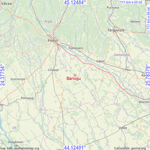
Bârlogu GPS coordinates[2]
44° 37' 35.688" North, 25° 4' 50.376" East
| Map corner | latitude | longitude |
|---|---|---|
| Upper-left | 45.12484°, | 24.37754° |
| Center: | 44.62658°, | 25.08066° |
| Lower-right: | 44.12401°, | 25.78379° |
| Map W x H: | 111.3×111.3 km | = 69.2×69.2mi |
| max Lat: | 48.23793° ⇑82.1% North |
| Bârlogu: | 44.62658° |
| min Lat: | ⇓17.9% South 43.65638° |
| min Long | Bârlogu | max Long |
| 20.31667° | 25.08066° | 29.65403° |
| W 48.4%⇐ | ⇒51.6% E |
Elevation
Elevation of Bârlogu is 217 m = 712 ft, and this is 37.9 m = 124 ft below average elevation for this country.
| Max E: |
1278 m = 4193 ft | 49% |
| Avg. | 254.9 m = 836 ft | |
| Bârlogu | 217 m = 712 ft | |
Min E: |
-2 m = -7 ft | 51% |
See also: Romania elevation on elevation.city.
Geographical zone
Bârlogu is located in North temperate zone (between Tropic of Cancer and the Arctic Circle). Distance of this Northern Tropic circle is 2356.1 km =1464 mi to South.| Distance of | km | miles | from Bârlogu |
|---|---|---|---|
| North Pole | 5045.1 | 3134.9 | to North |
| Arctic Circle | 2439.2 | 1515.6 | to North |
| Tropic Cancer | 2356.1 | 1464 | to South |
| Equator | 4962 | 3083.2 | to South |


Nearby cities:
15 places around Bârlogu: (largest is in red/bold)
• Babaroaga
12.5 km =7.8 mi,  134°
134°
• Cornățel
11.2 km =7 mi,  242°
242°
• Deagu de Sus
9.1 km =5.7 mi,  220°
220°
• Furduești
11 km =6.8 mi,  10°
10°
• Gliganu de Jos
4.9 km =3 mi,  314°
314°
• Gliganu de Sus
7 km =4.3 mi,  299°
299°
• Gruiu
12.1 km =7.5 mi,  356°
356°
• Mozăceni
9.5 km =5.9 mi, 134°
• Negraşi
4.1 km =2.5 mi,  136°
136°
• Recea
11.5 km =7.1 mi,  206°
206°
• Rociu
5.8 km =3.6 mi,  319°
319°
• Răteşti
12.6 km =7.8 mi,  19°
19°
• Teiu
4.7 km =2.9 mi, 18°
• Vulpești
11.4 km =7.1 mi,  253°
253°
• Șerbănești
9.3 km =5.8 mi, 311°
Sources, notices
• [Note1] Compared only with cities in Romania existing in our database
• [Src1] Map data: © OpenStreetMap contributors (CC-BY-SA)
• [Src2] Other city data from geonames.org with taken over terms of usage.
• [Src3] Geographical zone / Annual Mean Temperature by Robert A. Rohde @ Wikipedia
