Șerbănești geodata
Șerbănești (Arges) is a populated place; located in Romania in Europe/Bucharest (GMT+3) time zone. With population of 1,241 people, there are 3655 cities with bigger population in this country. Compared to other cities in Romania, 80.7% of cities are located further ↑North; 52.7% of cities are located further →East and 55.8% of cities have lower elevation than Șerbănești. Note1


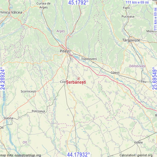
Șerbănești GPS coordinates[2]
44° 40' 53.112" North, 24° 59' 32.496" East
| Map corner | latitude | longitude |
|---|---|---|
| Upper-left | 45.1792°, | 24.28924° |
| Center: | 44.68142°, | 24.99236° |
| Lower-right: | 44.17932°, | 25.69549° |
| Map W x H: | 111.2×111.2 km | = 69.1×69.1mi |
| max Lat: | 48.23793° ⇑80.7% North |
| Șerbănești: | 44.68142° |
| min Lat: | ⇓19.3% South 43.65638° |
| min Long | Șerbănești | max Long |
| 20.31667° | 24.99236° | 29.65403° |
| W 47.3%⇐ | ⇒52.7% E |
Elevation
Elevation of Șerbănești is 242 m = 794 ft, and this is 12.9 m = 42 ft below average elevation for this country.
| Max E: |
1278 m = 4193 ft | 44.2% |
| Avg. | 254.9 m = 836 ft | |
| Șerbănești | 242 m = 794 ft | |
Min E: |
-2 m = -7 ft | 55.8% |
See also: Romania elevation on elevation.city.
Geographical zone
Șerbănești is located in North temperate zone (between Tropic of Cancer and the Arctic Circle). Distance of this Northern Tropic circle is 2362.2 km =1467.8 mi to South.| Distance of | km | miles | from Șerbănești |
|---|---|---|---|
| North Pole | 5039 | 3131.1 | to North |
| Arctic Circle | 2433.1 | 1511.9 | to North |
| Tropic Cancer | 2362.2 | 1467.8 | to South |
| Equator | 4968.1 | 3087 | to South |


Nearby cities:
15 places around Șerbănești: (largest is in red/bold)
• Bârlogu
9.3 km =5.8 mi,  131°
131°
• Cireșu
9.5 km =5.9 mi,  22°
22°
• Costeşti
8.8 km =5.5 mi,  259°
259°
• Furduești
10.1 km =6.3 mi,  62°
62°
• Gliganu de Jos
4.3 km =2.7 mi, 127°
• Gliganu de Sus
2.8 km =1.7 mi,  161°
161°
• Gruiu
8.6 km =5.3 mi,  45°
45°
• Oarja
8.9 km =5.5 mi,  351°
351°
• Oarja Sat
9.4 km =5.8 mi, 349°
• Pârvu Roșu
9.3 km =5.8 mi,  308°
308°
• Rociu
3.6 km =2.2 mi,  116°
116°
• Siliștea
7.6 km =4.7 mi,  32°
32°
• Suseni
5.2 km =3.2 mi,  319°
319°
• Teiu
8.7 km =5.4 mi,  100°
100°
• Șerboeni
9.2 km =5.7 mi,  238°
238°
Sources, notices
• [Note1] Compared only with cities in Romania existing in our database
• [Src1] Map data: © OpenStreetMap contributors (CC-BY-SA)
• [Src2] Other city data from geonames.org with taken over terms of usage.
• [Src3] Geographical zone / Annual Mean Temperature by Robert A. Rohde @ Wikipedia
