Avrămești geodata
Avrămești (Vaslui) is a populated place; located in Romania in Europe/Bucharest (GMT+3) time zone. With population of 709 people, there are 5514 cities with bigger population in this country. Compared to other cities in Romania, 68.3% of cities are located further ↓South; 89.2% of cities are located further ←West and 52.1% of cities have higher elevation than Avrămești. Note1


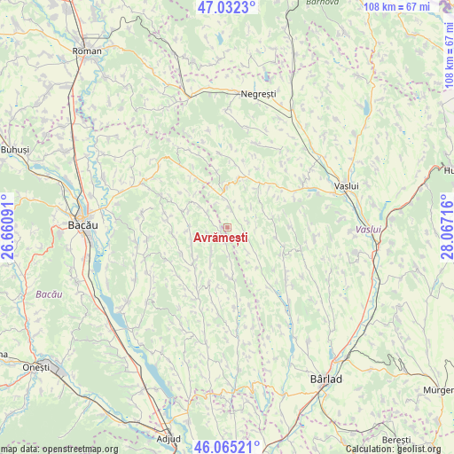
Avrămești GPS coordinates[2]
46° 33' 3.276" North, 27° 21' 50.508" East
| Map corner | latitude | longitude |
|---|---|---|
| Upper-left | 47.0323°, | 26.66091° |
| Center: | 46.55091°, | 27.36403° |
| Lower-right: | 46.06521°, | 28.06716° |
| Map W x H: | 107.5×107.5 km | = 66.8×66.8mi |
| max Lat: | 48.23793° ⇑31.7% North |
| Avrămești: | 46.55091° |
| min Lat: | ⇓68.3% South 43.65638° |
| min Long | Avrămești | max Long |
| 20.31667° | 27.36403° | 29.65403° |
| W 89.2%⇐ | ⇒10.8% E |
Elevation
Elevation of Avrămești is 201 m = 659 ft, and this is 53.9 m = 177 ft below average elevation for this country.
| Max E: |
1278 m = 4193 ft | 52.1% |
| Avg. | 254.9 m = 836 ft | |
| Avrămești | 201 m = 659 ft | |
Min E: |
-2 m = -7 ft | 47.9% |
See also: Romania elevation on elevation.city.
Geographical zone
Avrămești is located in North temperate zone (between Tropic of Cancer and the Arctic Circle). Distance of this North polar circle is 2225.2 km =1382.7 mi to North.| Distance of | km | miles | from Avrămești |
|---|---|---|---|
| North Pole | 4831.1 | 3001.9 | to North |
| Arctic Circle | 2225.2 | 1382.7 | to North |
| Tropic Cancer | 2570.1 | 1597 | to South |
| Equator | 5176 | 3216.2 | to South |


Nearby cities:
15 places around Avrămești: (largest is in red/bold)
• Barcana
7 km =4.3 mi,  181°
181°
• Coloneşti
5.2 km =3.2 mi,  289°
289°
• Doagele
13.5 km =8.4 mi,  349°
349°
• Dragomireşti
9.2 km =5.7 mi, 353°
• Ghergheşti
13 km =8.1 mi,  115°
115°
• Gârdești
6.6 km =4.1 mi,  90°
90°
• Ivănești
11.9 km =7.4 mi,  38°
38°
• Izvoru Berheciului
11.8 km =7.3 mi, 287°
• Onceşti
12.8 km =8 mi,  222°
222°
• Răchitoasa
13.1 km =8.1 mi, 179°
• Rădeni
4.5 km =2.8 mi,  11°
11°
• Slobozia
9.4 km =5.8 mi,  205°
205°
• Slobozia Nouă
5.2 km =3.2 mi,  256°
256°
• Tarnița
9.1 km =5.7 mi,  248°
248°
• Voineşti
4.4 km =2.7 mi,  66°
66°
Sources, notices
• [Note1] Compared only with cities in Romania existing in our database
• [Src1] Map data: © OpenStreetMap contributors (CC-BY-SA)
• [Src2] Other city data from geonames.org with taken over terms of usage.
• [Src3] Geographical zone / Annual Mean Temperature by Robert A. Rohde @ Wikipedia
