Topliţa geodata
Topliţa (Hunedoara) is a seat of a second-order administrative division; located in Romania in Europe/Bucharest (GMT+3) time zone. With population of 870 people, there are 4746 cities with bigger population in this country. Compared to other cities in Romania, 52.4% of cities are located further ↑North; 87.4% of cities are located further →East and 85.5% of cities have lower elevation than Topliţa. Note1


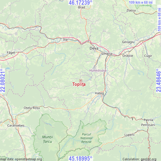
Topliţa GPS coordinates[2]
45° 40' 59.988" North, 22° 46' 59.988" East
| Map corner | latitude | longitude |
|---|---|---|
| Upper-left | 46.17239°, | 22.08021° |
| Center: | 45.68333°, | 22.78333° |
| Lower-right: | 45.18995°, | 23.48646° |
| Map W x H: | 109.2×109.2 km | = 67.9×67.9mi |
| max Lat: | 48.23793° ⇑52.4% North |
| Topliţa: | 45.68333° |
| min Lat: | ⇓47.6% South 43.65638° |
| min Long | Topliţa | max Long |
| 20.31667° | 22.78333° | 29.65403° |
| W 12.6%⇐ | ⇒87.4% E |
Elevation
Elevation of Topliţa is 452 m = 1483 ft, and this is 197.1 m = 647 ft above average elevation for this country.
| Max E: |
1278 m = 4193 ft | 14.5% |
| Topliţa | 452 m 1483 ft | |
| Avg. | 254.9 m = 836 ft | |
Min E: |
-2 m = -7 ft | 85.5% |
See also: Romania elevation on elevation.city.
Geographical zone
Topliţa is located in North temperate zone (between Tropic of Cancer and the Arctic Circle). Distance of this North polar circle is 2321.7 km =1442.6 mi to North.| Distance of | km | miles | from Topliţa |
|---|---|---|---|
| North Pole | 4927.6 | 3061.9 | to North |
| Arctic Circle | 2321.7 | 1442.6 | to North |
| Tropic Cancer | 2473.6 | 1537 | to South |
| Equator | 5079.5 | 3156.3 | to South |


Nearby cities:
15 places around Topliţa: (largest is in red/bold)
• Bunila
9.2 km =5.7 mi,  281°
281°
• Cerbăl
12.3 km =7.6 mi,  335°
335°
• Cinciș-Cerna
8.7 km =5.4 mi,  76°
76°
• Densuş
11.2 km =7 mi,  173°
173°
• General Berthelot
10.7 km =6.6 mi,  133°
133°
• Ghelari
3.7 km =2.3 mi,  0°
0°
• Haţeg
14.9 km =9.3 mi,  119°
119°
• Hunedoara
11.7 km =7.3 mi,  50°
50°
• Lelese
8.5 km =5.3 mi,  310°
310°
• Lunca Cernii de Jos
14.1 km =8.8 mi,  246°
246°
• Peştişu Mic
15.1 km =9.4 mi,  30°
30°
• Răchitova
9.6 km =6 mi,  195°
195°
• Răcăștia
11.7 km =7.3 mi,  36°
36°
• Teliucu Inferior
8.6 km =5.3 mi,  64°
64°
• Toteşti
15.1 km =9.4 mi,  149°
149°
Sources, notices
• [Note1] Compared only with cities in Romania existing in our database
• [Src1] Map data: © OpenStreetMap contributors (CC-BY-SA)
• [Src2] Other city data from geonames.org with taken over terms of usage.
• [Src3] Geographical zone / Annual Mean Temperature by Robert A. Rohde @ Wikipedia
