Ghelari geodata
Ghelari (Hunedoara) is a seat of a second-order administrative division; located in Romania in Europe/Bucharest (GMT+3) time zone. With population of 1,670 people, there are 2959 cities with bigger population in this country. Compared to other cities in Romania, 51.7% of cities are located further ↑North; 87.4% of cities are located further →East and 95.1% of cities have lower elevation than Ghelari. Note1


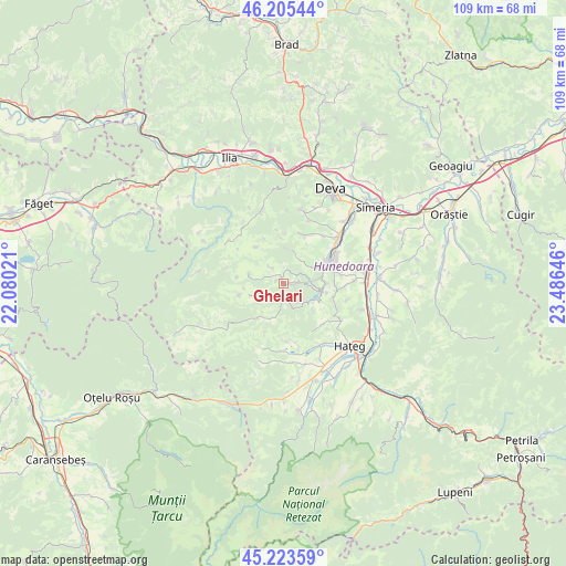
Ghelari GPS coordinates[2]
45° 43' 0.012" North, 22° 46' 59.988" East
| Map corner | latitude | longitude |
|---|---|---|
| Upper-left | 46.20544°, | 22.08021° |
| Center: | 45.71667°, | 22.78333° |
| Lower-right: | 45.22359°, | 23.48646° |
| Map W x H: | 109.2×109.2 km | = 67.9×67.9mi |
| max Lat: | 48.23793° ⇑51.7% North |
| Ghelari: | 45.71667° |
| min Lat: | ⇓48.3% South 43.65638° |
| min Long | Ghelari | max Long |
| 20.31667° | 22.78333° | 29.65403° |
| W 12.6%⇐ | ⇒87.4% E |
Elevation
Elevation of Ghelari is 630 m = 2067 ft, and this is 375.1 m = 1231 ft above average elevation for this country.
| Max E: |
1278 m = 4193 ft | 4.9% |
| Ghelari | 630 m 2067 ft | |
| Avg. | 254.9 m = 836 ft | |
Min E: |
-2 m = -7 ft | 95.1% |
See also: Romania elevation on elevation.city.
Geographical zone
Ghelari is located in North temperate zone (between Tropic of Cancer and the Arctic Circle). Distance of this North polar circle is 2318 km =1440.3 mi to North.| Distance of | km | miles | from Ghelari |
|---|---|---|---|
| North Pole | 4923.8 | 3059.5 | to North |
| Arctic Circle | 2318 | 1440.3 | to North |
| Tropic Cancer | 2477.3 | 1539.3 | to South |
| Equator | 5083.2 | 3158.6 | to South |


Nearby cities:
15 places around Ghelari: (largest is in red/bold)
• Bunila
9.2 km =5.7 mi,  258°
258°
• Cerbăl
9 km =5.6 mi,  325°
325°
• Cinciș-Cerna
8.6 km =5.3 mi,  101°
101°
• Cârjiţi
15.3 km =9.5 mi,  14°
14°
• Călan
15.6 km =9.7 mi,  83°
83°
• Densuş
14.9 km =9.3 mi,  175°
175°
• General Berthelot
13.6 km =8.5 mi,  145°
145°
• Hunedoara
9.8 km =6.1 mi,  67°
67°
• Lelese
6.7 km =4.2 mi,  285°
285°
• Peştişu Mic
12.1 km =7.5 mi,  39°
39°
• Peștișu Mare
14.6 km =9.1 mi,  49°
49°
• Răchitova
13.2 km =8.2 mi,  191°
191°
• Răcăștia
9 km =5.6 mi, 51°
• Teliucu Inferior
7.8 km =4.8 mi,  90°
90°
• Topliţa
3.7 km =2.3 mi, 180°
Sources, notices
• [Note1] Compared only with cities in Romania existing in our database
• [Src1] Map data: © OpenStreetMap contributors (CC-BY-SA)
• [Src2] Other city data from geonames.org with taken over terms of usage.
• [Src3] Geographical zone / Annual Mean Temperature by Robert A. Rohde @ Wikipedia
